You are here: Home > Network List > TA - USArray Transportable Network (new EarthScope stations) Stations List
> Station H20A Greybull, WY, USA > Earthquake Result Viewer
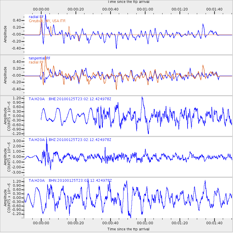
H20A Greybull, WY, USA - Earthquake Result Viewer
*The percent match for this event was below the threshold and hence no stack was calculated.
| Earthquake location: |
Peru-Brazil Border Region |
| Earthquake latitude/longitude: |
-8.5/-74.5 |
| Earthquake time(UTC): |
2010/01/25 (025) 22:52:46 GMT |
| Earthquake Depth: |
147 km |
| Earthquake Magnitude: |
5.7 MB, 5.9 MW, 5.9 MW |
| Earthquake Catalog/Contributor: |
WHDF/NEIC |
|
| Network: |
TA USArray Transportable Network (new EarthScope stations) |
| Station: |
H20A Greybull, WY, USA |
| Lat/Lon: |
44.49 N/108.00 W |
| Elevation: |
1236 m |
|
| Distance: |
60.8 deg |
| Az: |
333.07 deg |
| Baz: |
141.252 deg |
| Ray Param: |
$rayparam |
*The percent match for this event was below the threshold and hence was not used in the summary stack. |
|
| Radial Match: |
68.20178 % |
| Radial Bump: |
400 |
| Transverse Match: |
52.168697 % |
| Transverse Bump: |
400 |
| SOD ConfigId: |
296938 |
| Insert Time: |
2010-04-06 23:26:58.691 +0000 |
| GWidth: |
2.5 |
| Max Bumps: |
400 |
| Tol: |
0.001 |
|
Signal To Noise
| Channel | StoN | STA | LTA |
| TA:H20A: :BHZ:20100125T23:02:12.424978Z | 4.17892 | 1.1069262E-6 | 2.6488334E-7 |
| TA:H20A: :BHN:20100125T23:02:12.424978Z | 1.8219922 | 6.7205764E-7 | 3.6885868E-7 |
| TA:H20A: :BHE:20100125T23:02:12.424978Z | 1.403151 | 4.3474407E-7 | 3.0983412E-7 |
| Arrivals |
| Ps | |
| PpPs | |
| PsPs/PpSs | |


