You are here: Home > Network List > XA95 - Missouri to Massachusetts Transect Stations List
> Station MM12 Laura, Ohio > Earthquake Result Viewer
MM12 Laura, Ohio - Earthquake Result Viewer
| Earthquake location: |
Egypt |
| Earthquake latitude/longitude: |
28.8/34.9 |
| Earthquake time(UTC): |
1995/11/22 (326) 04:15:11 GMT |
| Earthquake Depth: |
10 km |
| Earthquake Magnitude: |
6.2 MB, 7.3 MS, 7.2 UNKNOWN, 6.2 ML |
| Earthquake Catalog/Contributor: |
WHDF/NEIC |
|
| Network: |
XA Missouri to Massachusetts Transect |
| Station: |
MM12 Laura, Ohio |
| Lat/Lon: |
40.04 N/84.37 W |
| Elevation: |
305 m |
|
| Distance: |
91.2 deg |
| Az: |
317.928 deg |
| Baz: |
49.99 deg |
| Ray Param: |
0.041616023 |
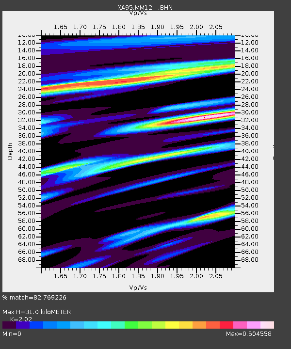
| Estimated Moho Depth: |
31.0 km |
| Estimated Crust Vp/Vs: |
2.02 |
| Assumed Crust Vp: |
6.498 km/s |
| Estimated Crust Vs: |
3.217 km/s |
| Estimated Crust Poisson's Ratio: |
0.34 |
|
| Radial Match: |
82.769226 % |
| Radial Bump: |
400 |
| Transverse Match: |
69.54408 % |
| Transverse Bump: |
400 |
| SOD ConfigId: |
29242 |
| Insert Time: |
2010-02-26 17:52:13.760 +0000 |
| GWidth: |
2.5 |
| Max Bumps: |
400 |
| Tol: |
0.001 |
|

Signal To Noise
| Channel | StoN | STA | LTA |
| XA:MM12: :BHN:19951122T04:27:45.476001Z | 0.41722143 | 1.1256846E-7 | 2.698051E-7 |
| XA:MM12: :BHE:19951122T04:27:45.476001Z | 0.51213396 | 1.321312E-7 | 2.5800128E-7 |
| XA:MM12: :BHZ:19951122T04:27:45.476001Z | 1.261678 | 3.6385993E-7 | 2.8839364E-7 |
| Arrivals |
| Ps | 5.0 SECOND |
| PpPs | 14 SECOND |
| PsPs/PpSs | 19 SECOND |


