You are here: Home > Network List > XA95 - Missouri to Massachusetts Transect Stations List
> Station MM12 Laura, Ohio > Earthquake Result Viewer
MM12 Laura, Ohio - Earthquake Result Viewer
| Earthquake location: |
Kuril Islands |
| Earthquake latitude/longitude: |
44.6/149.4 |
| Earthquake time(UTC): |
1995/12/03 (337) 18:01:08 GMT |
| Earthquake Depth: |
33 km |
| Earthquake Magnitude: |
6.6 MB, 8.0 MS |
| Earthquake Catalog/Contributor: |
WHDF/NEIC |
|
| Network: |
XA Missouri to Massachusetts Transect |
| Station: |
MM12 Laura, Ohio |
| Lat/Lon: |
40.04 N/84.37 W |
| Elevation: |
305 m |
|
| Distance: |
82.9 deg |
| Az: |
38.598 deg |
| Baz: |
324.489 deg |
| Ray Param: |
0.046526603 |
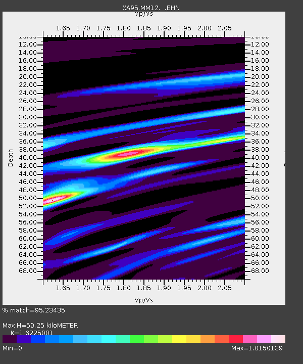
| Estimated Moho Depth: |
50.25 km |
| Estimated Crust Vp/Vs: |
1.62 |
| Assumed Crust Vp: |
6.498 km/s |
| Estimated Crust Vs: |
4.005 km/s |
| Estimated Crust Poisson's Ratio: |
0.19 |
|
| Radial Match: |
95.23435 % |
| Radial Bump: |
400 |
| Transverse Match: |
85.84377 % |
| Transverse Bump: |
400 |
| SOD ConfigId: |
6273 |
| Insert Time: |
2010-02-26 17:52:14.624 +0000 |
| GWidth: |
2.5 |
| Max Bumps: |
400 |
| Tol: |
0.001 |
|

Signal To Noise
| Channel | StoN | STA | LTA |
| XA:MM12: :BHN:19951203T18:12:58.669006Z | 1.0814949 | 6.344015E-7 | 5.8659685E-7 |
| XA:MM12: :BHE:19951203T18:12:58.669006Z | 1.3190035 | 6.792936E-7 | 5.150052E-7 |
| XA:MM12: :BHZ:19951203T18:12:58.669006Z | 3.5560646 | 2.3974615E-6 | 6.7418955E-7 |
| Arrivals |
| Ps | 5.0 SECOND |
| PpPs | 20 SECOND |
| PsPs/PpSs | 25 SECOND |


