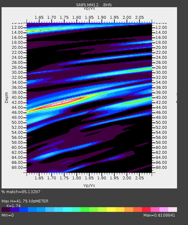
MM12 Laura, Ohio - Earthquake Result Viewer

Earthquake location: Peru-Ecuador Border Region
Earthquake latitude/longitude: -2.8/-77.9
Earthquake time(UTC): 1995/10/03 (276) 12:45:00 GMT
Earthquake Depth: 33 km
Earthquake Magnitude: 6.0 MB, 6.1 MS, 5.9 UNKNOWN, 6.4 MW
Earthquake Catalog/Contributor: WHDF/NEIC
Network: XA Missouri to Massachusetts Transect
Station: MM12 Laura, Ohio
Lat/Lon: 40.04 N/84.37 W
Elevation: 305 m
Distance: 43.1 deg
Az: 352.716 deg
Baz: 170.504 deg
Ray Param: 0.07272533
Estimated Moho Depth: 41.75 km
Estimated Crust Vp/Vs: 1.74
Assumed Crust Vp: 6.498 km/s
Estimated Crust Vs: 3.734 km/s
Estimated Crust Poisson's Ratio: 0.25
Radial Match: 85.13287 %
Radial Bump: 373
Transverse Match: 67.99181 %
Transverse Bump: 400
SOD ConfigId: 6273
Insert Time: 2010-02-26 17:52:16.567 +0000
GWidth: 2.5
Max Bumps: 400
Tol: 0.001

Signal To Noise

ChannelStoNSTALTA
XA:MM12: :BHN:19951003T12:52:26.326013Z4.7399427.172155E-71.5131315E-7
XA:MM12: :BHE:19951003T12:52:26.326013Z1.06739141.7876259E-71.6747613E-7
XA:MM12: :BHZ:19951003T12:52:26.326013Z6.6646491.2636888E-61.896107E-7
Arrivals
Ps5.1 SECOND
PpPs16 SECOND
PsPs/PpSs22 SECOND