You are here: Home > Network List > UM - University of Montana - Missoula Stations List
> Station LGMT Long Gulch > Earthquake Result Viewer
LGMT Long Gulch - Earthquake Result Viewer
| Earthquake location: |
Rat Islands, Aleutian Islands |
| Earthquake latitude/longitude: |
52.4/176.8 |
| Earthquake time(UTC): |
2017/10/08 (281) 22:34:33 GMT |
| Earthquake Depth: |
112 km |
| Earthquake Magnitude: |
6.6 mww |
| Earthquake Catalog/Contributor: |
NEIC PDE/us |
|
| Network: |
UM University of Montana - Missoula |
| Station: |
LGMT Long Gulch |
| Lat/Lon: |
46.88 N/112.61 W |
| Elevation: |
1784 m |
|
| Distance: |
44.4 deg |
| Az: |
67.723 deg |
| Baz: |
304.347 deg |
| Ray Param: |
0.07158568 |
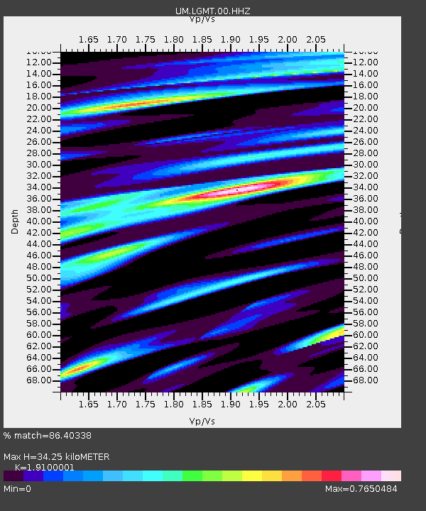
| Estimated Moho Depth: |
34.25 km |
| Estimated Crust Vp/Vs: |
1.91 |
| Assumed Crust Vp: |
6.353 km/s |
| Estimated Crust Vs: |
3.326 km/s |
| Estimated Crust Poisson's Ratio: |
0.31 |
|
| Radial Match: |
86.40338 % |
| Radial Bump: |
383 |
| Transverse Match: |
72.702614 % |
| Transverse Bump: |
400 |
| SOD ConfigId: |
2973751 |
| Insert Time: |
2018-10-09 00:09:04.146 +0000 |
| GWidth: |
2.5 |
| Max Bumps: |
400 |
| Tol: |
0.001 |
|

Signal To Noise
| Channel | StoN | STA | LTA |
| UM:LGMT:00:HHZ:20171008T22:42:02.630013Z | 11.946416 | 3.7595337E-6 | 3.1469972E-7 |
| UM:LGMT:00:HHN:20171008T22:42:02.630013Z | 6.7660723 | 1.258337E-6 | 1.8597747E-7 |
| UM:LGMT:00:HHE:20171008T22:42:02.630013Z | 5.235964 | 1.6674262E-6 | 3.184564E-7 |
| Arrivals |
| Ps | 5.2 SECOND |
| PpPs | 15 SECOND |
| PsPs/PpSs | 20 SECOND |


