You are here: Home > Network List > TA - USArray Transportable Network (new EarthScope stations) Stations List
> Station 130A Snyder, TX, USA > Earthquake Result Viewer
130A Snyder, TX, USA - Earthquake Result Viewer
*The percent match for this event was below the threshold and hence no stack was calculated.
| Earthquake location: |
Peru-Brazil Border Region |
| Earthquake latitude/longitude: |
-8.5/-74.5 |
| Earthquake time(UTC): |
2010/01/25 (025) 22:52:46 GMT |
| Earthquake Depth: |
147 km |
| Earthquake Magnitude: |
5.7 MB, 5.9 MW, 5.9 MW |
| Earthquake Catalog/Contributor: |
WHDF/NEIC |
|
| Network: |
TA USArray Transportable Network (new EarthScope stations) |
| Station: |
130A Snyder, TX, USA |
| Lat/Lon: |
32.60 N/100.97 W |
| Elevation: |
676 m |
|
| Distance: |
48.0 deg |
| Az: |
329.572 deg |
| Baz: |
143.596 deg |
| Ray Param: |
$rayparam |
*The percent match for this event was below the threshold and hence was not used in the summary stack. |
|
| Radial Match: |
56.240623 % |
| Radial Bump: |
400 |
| Transverse Match: |
70.27613 % |
| Transverse Bump: |
400 |
| SOD ConfigId: |
296938 |
| Insert Time: |
2010-04-06 23:38:03.072 +0000 |
| GWidth: |
2.5 |
| Max Bumps: |
400 |
| Tol: |
0.001 |
|
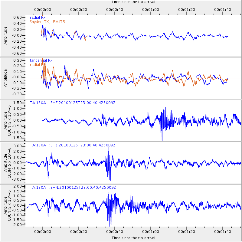
Signal To Noise
| Channel | StoN | STA | LTA |
| TA:130A: :BHZ:20100125T23:00:40.425009Z | 7.392386 | 9.152227E-7 | 1.2380613E-7 |
| TA:130A: :BHN:20100125T23:00:40.425009Z | 2.5419734 | 3.613658E-7 | 1.4215956E-7 |
| TA:130A: :BHE:20100125T23:00:40.425009Z | 2.4510643 | 2.3536188E-7 | 9.602436E-8 |
| Arrivals |
| Ps | |
| PpPs | |
| PsPs/PpSs | |


