You are here: Home > Network List > AK - Alaska Regional Network Stations List
> Station BAE Barry Arm East, AK, USA > Earthquake Result Viewer
BAE Barry Arm East, AK, USA - Earthquake Result Viewer
| Earthquake location: |
Solomon Islands |
| Earthquake latitude/longitude: |
-9.8/159.6 |
| Earthquake time(UTC): |
2022/11/22 (326) 02:03:07 GMT |
| Earthquake Depth: |
14 km |
| Earthquake Magnitude: |
7.0 Mww |
| Earthquake Catalog/Contributor: |
NEIC PDE/us |
|
| Network: |
AK Alaska Regional Network |
| Station: |
BAE Barry Arm East, AK, USA |
| Lat/Lon: |
61.13 N/148.12 W |
| Elevation: |
578 m |
|
| Distance: |
81.7 deg |
| Az: |
22.829 deg |
| Baz: |
231.996 deg |
| Ray Param: |
0.047407616 |
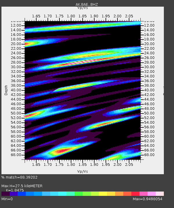
| Estimated Moho Depth: |
27.5 km |
| Estimated Crust Vp/Vs: |
1.85 |
| Assumed Crust Vp: |
6.566 km/s |
| Estimated Crust Vs: |
3.554 km/s |
| Estimated Crust Poisson's Ratio: |
0.29 |
|
| Radial Match: |
88.39202 % |
| Radial Bump: |
400 |
| Transverse Match: |
80.17514 % |
| Transverse Bump: |
400 |
| SOD ConfigId: |
29823551 |
| Insert Time: |
2022-12-06 02:04:14.412 +0000 |
| GWidth: |
2.5 |
| Max Bumps: |
400 |
| Tol: |
0.001 |
|

Signal To Noise
| Channel | StoN | STA | LTA |
| AK:BAE: :BHZ:20221122T02:14:53.38798Z | 30.564905 | 4.4135327E-6 | 1.443987E-7 |
| AK:BAE: :BHN:20221122T02:14:53.38798Z | 6.6306973 | 1.1381326E-6 | 1.71646E-7 |
| AK:BAE: :BHE:20221122T02:14:53.38798Z | 9.134862 | 1.6135428E-6 | 1.7663571E-7 |
| Arrivals |
| Ps | 3.6 SECOND |
| PpPs | 12 SECOND |
| PsPs/PpSs | 15 SECOND |


