You are here: Home > Network List > AK - Alaska Regional Network Stations List
> Station BRSE Bradley Lake South, AK, USA > Earthquake Result Viewer
BRSE Bradley Lake South, AK, USA - Earthquake Result Viewer
| Earthquake location: |
Solomon Islands |
| Earthquake latitude/longitude: |
-9.8/159.6 |
| Earthquake time(UTC): |
2022/11/22 (326) 02:03:07 GMT |
| Earthquake Depth: |
14 km |
| Earthquake Magnitude: |
7.0 Mww |
| Earthquake Catalog/Contributor: |
NEIC PDE/us |
|
| Network: |
AK Alaska Regional Network |
| Station: |
BRSE Bradley Lake South, AK, USA |
| Lat/Lon: |
59.74 N/150.74 W |
| Elevation: |
541 m |
|
| Distance: |
79.8 deg |
| Az: |
23.096 deg |
| Baz: |
229.765 deg |
| Ray Param: |
0.048706833 |
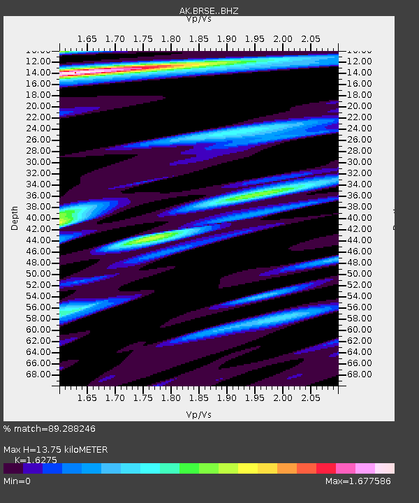
| Estimated Moho Depth: |
13.75 km |
| Estimated Crust Vp/Vs: |
1.63 |
| Assumed Crust Vp: |
6.24 km/s |
| Estimated Crust Vs: |
3.834 km/s |
| Estimated Crust Poisson's Ratio: |
0.20 |
|
| Radial Match: |
89.288246 % |
| Radial Bump: |
400 |
| Transverse Match: |
87.28304 % |
| Transverse Bump: |
400 |
| SOD ConfigId: |
29823551 |
| Insert Time: |
2022-12-06 02:04:34.343 +0000 |
| GWidth: |
2.5 |
| Max Bumps: |
400 |
| Tol: |
0.001 |
|

Signal To Noise
| Channel | StoN | STA | LTA |
| AK:BRSE: :BHZ:20221122T02:14:43.327983Z | 15.831057 | 5.6184167E-6 | 3.5489842E-7 |
| AK:BRSE: :BHN:20221122T02:14:43.327983Z | 3.3141599 | 1.2542365E-6 | 3.7844782E-7 |
| AK:BRSE: :BHE:20221122T02:14:43.327983Z | 4.4840827 | 1.7516023E-6 | 3.9062667E-7 |
| Arrivals |
| Ps | 1.4 SECOND |
| PpPs | 5.6 SECOND |
| PsPs/PpSs | 7.0 SECOND |


