You are here: Home > Network List > AK - Alaska Regional Network Stations List
> Station I27K Kandik River, AK, USA > Earthquake Result Viewer
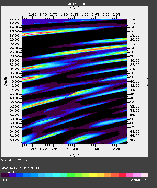
I27K Kandik River, AK, USA - Earthquake Result Viewer
| Earthquake location: |
Solomon Islands |
| Earthquake latitude/longitude: |
-9.8/159.6 |
| Earthquake time(UTC): |
2022/11/22 (326) 02:03:07 GMT |
| Earthquake Depth: |
14 km |
| Earthquake Magnitude: |
7.0 Mww |
| Earthquake Catalog/Contributor: |
NEIC PDE/us |
|
| Network: |
AK Alaska Regional Network |
| Station: |
I27K Kandik River, AK, USA |
| Lat/Lon: |
65.60 N/141.62 W |
| Elevation: |
874 m |
|
| Distance: |
86.7 deg |
| Az: |
20.847 deg |
| Baz: |
237.61 deg |
| Ray Param: |
0.043878376 |
| Estimated Moho Depth: |
17.25 km |
| Estimated Crust Vp/Vs: |
1.61 |
| Assumed Crust Vp: |
6.566 km/s |
| Estimated Crust Vs: |
4.078 km/s |
| Estimated Crust Poisson's Ratio: |
0.19 |
|
| Radial Match: |
93.19888 % |
| Radial Bump: |
400 |
| Transverse Match: |
82.801125 % |
| Transverse Bump: |
400 |
| SOD ConfigId: |
29823551 |
| Insert Time: |
2022-12-06 02:06:18.850 +0000 |
| GWidth: |
2.5 |
| Max Bumps: |
400 |
| Tol: |
0.001 |
|

Signal To Noise
| Channel | StoN | STA | LTA |
| AK:I27K: :BHZ:20221122T02:15:18.619975Z | 21.321259 | 4.398329E-6 | 2.0628843E-7 |
| AK:I27K: :BHN:20221122T02:15:18.619975Z | 4.199993 | 8.950285E-7 | 2.1310238E-7 |
| AK:I27K: :BHE:20221122T02:15:18.619975Z | 7.5328703 | 1.3536547E-6 | 1.7969974E-7 |
| Arrivals |
| Ps | 1.6 SECOND |
| PpPs | 6.7 SECOND |
| PsPs/PpSs | 8.3 SECOND |


