You are here: Home > Network List > AK - Alaska Regional Network Stations List
> Station K20K Telida, AK, USA > Earthquake Result Viewer
K20K Telida, AK, USA - Earthquake Result Viewer
| Earthquake location: |
Solomon Islands |
| Earthquake latitude/longitude: |
-9.8/159.6 |
| Earthquake time(UTC): |
2022/11/22 (326) 02:03:07 GMT |
| Earthquake Depth: |
14 km |
| Earthquake Magnitude: |
7.0 Mww |
| Earthquake Catalog/Contributor: |
NEIC PDE/us |
|
| Network: |
AK Alaska Regional Network |
| Station: |
K20K Telida, AK, USA |
| Lat/Lon: |
63.36 N/154.07 W |
| Elevation: |
548 m |
|
| Distance: |
81.0 deg |
| Az: |
19.281 deg |
| Baz: |
226.206 deg |
| Ray Param: |
0.047858123 |
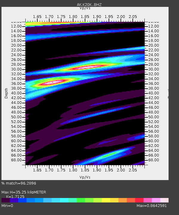
| Estimated Moho Depth: |
35.25 km |
| Estimated Crust Vp/Vs: |
1.71 |
| Assumed Crust Vp: |
6.438 km/s |
| Estimated Crust Vs: |
3.76 km/s |
| Estimated Crust Poisson's Ratio: |
0.24 |
|
| Radial Match: |
96.2896 % |
| Radial Bump: |
308 |
| Transverse Match: |
81.4766 % |
| Transverse Bump: |
400 |
| SOD ConfigId: |
29823551 |
| Insert Time: |
2022-12-06 02:06:36.099 +0000 |
| GWidth: |
2.5 |
| Max Bumps: |
400 |
| Tol: |
0.001 |
|

Signal To Noise
| Channel | StoN | STA | LTA |
| AK:K20K: :BHZ:20221122T02:14:49.980021Z | 35.609646 | 5.0699964E-6 | 1.4237705E-7 |
| AK:K20K: :BHN:20221122T02:14:49.980021Z | 6.617573 | 1.192311E-6 | 1.8017346E-7 |
| AK:K20K: :BHE:20221122T02:14:49.980021Z | 8.189816 | 1.050061E-6 | 1.2821545E-7 |
| Arrivals |
| Ps | 4.0 SECOND |
| PpPs | 14 SECOND |
| PsPs/PpSs | 18 SECOND |


