You are here: Home > Network List > AK - Alaska Regional Network Stations List
> Station M11K Mekoryuk, AK, USA > Earthquake Result Viewer
M11K Mekoryuk, AK, USA - Earthquake Result Viewer
| Earthquake location: |
Solomon Islands |
| Earthquake latitude/longitude: |
-9.8/159.6 |
| Earthquake time(UTC): |
2022/11/22 (326) 02:03:07 GMT |
| Earthquake Depth: |
14 km |
| Earthquake Magnitude: |
7.0 Mww |
| Earthquake Catalog/Contributor: |
NEIC PDE/us |
|
| Network: |
AK Alaska Regional Network |
| Station: |
M11K Mekoryuk, AK, USA |
| Lat/Lon: |
60.38 N/166.20 W |
| Elevation: |
3.0 m |
|
| Distance: |
75.1 deg |
| Az: |
16.8 deg |
| Baz: |
214.997 deg |
| Ray Param: |
0.0519178 |
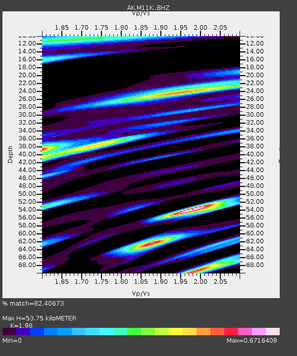
| Estimated Moho Depth: |
53.75 km |
| Estimated Crust Vp/Vs: |
1.98 |
| Assumed Crust Vp: |
6.134 km/s |
| Estimated Crust Vs: |
3.098 km/s |
| Estimated Crust Poisson's Ratio: |
0.33 |
|
| Radial Match: |
82.40673 % |
| Radial Bump: |
400 |
| Transverse Match: |
63.51274 % |
| Transverse Bump: |
400 |
| SOD ConfigId: |
29823551 |
| Insert Time: |
2022-12-06 02:07:05.924 +0000 |
| GWidth: |
2.5 |
| Max Bumps: |
400 |
| Tol: |
0.001 |
|

Signal To Noise
| Channel | StoN | STA | LTA |
| AK:M11K: :BHZ:20221122T02:14:16.860026Z | 4.3587737 | 3.6130957E-6 | 8.289248E-7 |
| AK:M11K: :BHN:20221122T02:14:16.860026Z | 1.1590428 | 1.209108E-6 | 1.0431952E-6 |
| AK:M11K: :BHE:20221122T02:14:16.860026Z | 0.8830428 | 7.9809706E-7 | 9.038033E-7 |
| Arrivals |
| Ps | 8.8 SECOND |
| PpPs | 25 SECOND |
| PsPs/PpSs | 34 SECOND |


