You are here: Home > Network List > TA - USArray Transportable Network (new EarthScope stations) Stations List
> Station L28A Connealy Angus Ranch, Whitman, NE, USA > Earthquake Result Viewer
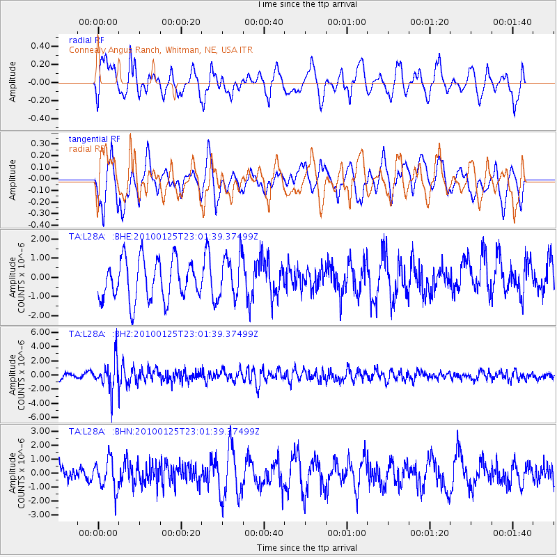
L28A Connealy Angus Ranch, Whitman, NE, USA - Earthquake Result Viewer
*The percent match for this event was below the threshold and hence no stack was calculated.
| Earthquake location: |
Peru-Brazil Border Region |
| Earthquake latitude/longitude: |
-8.5/-74.5 |
| Earthquake time(UTC): |
2010/01/25 (025) 22:52:46 GMT |
| Earthquake Depth: |
147 km |
| Earthquake Magnitude: |
5.7 MB, 5.9 MW, 5.9 MW |
| Earthquake Catalog/Contributor: |
WHDF/NEIC |
|
| Network: |
TA USArray Transportable Network (new EarthScope stations) |
| Station: |
L28A Connealy Angus Ranch, Whitman, NE, USA |
| Lat/Lon: |
42.01 N/101.52 W |
| Elevation: |
1155 m |
|
| Distance: |
56.0 deg |
| Az: |
335.877 deg |
| Baz: |
147.15 deg |
| Ray Param: |
$rayparam |
*The percent match for this event was below the threshold and hence was not used in the summary stack. |
|
| Radial Match: |
43.93877 % |
| Radial Bump: |
400 |
| Transverse Match: |
51.80584 % |
| Transverse Bump: |
400 |
| SOD ConfigId: |
296938 |
| Insert Time: |
2010-04-06 23:42:33.685 +0000 |
| GWidth: |
2.5 |
| Max Bumps: |
400 |
| Tol: |
0.001 |
|
Signal To Noise
| Channel | StoN | STA | LTA |
| TA:L28A: :BHZ:20100125T23:01:39.37499Z | 6.03946 | 2.1670264E-6 | 3.5881126E-7 |
| TA:L28A: :BHN:20100125T23:01:39.37499Z | 1.1172136 | 1.1165594E-6 | 9.994145E-7 |
| TA:L28A: :BHE:20100125T23:01:39.37499Z | 1.0803161 | 1.1295367E-6 | 1.0455614E-6 |
| Arrivals |
| Ps | |
| PpPs | |
| PsPs/PpSs | |


