You are here: Home > Network List > XA95 - Missouri to Massachusetts Transect Stations List
> Station MM12 Laura, Ohio > Earthquake Result Viewer
MM12 Laura, Ohio - Earthquake Result Viewer
| Earthquake location: |
Kuril Islands |
| Earthquake latitude/longitude: |
44.1/148.1 |
| Earthquake time(UTC): |
1995/04/28 (118) 16:30:00 GMT |
| Earthquake Depth: |
29 km |
| Earthquake Magnitude: |
6.6 MB, 6.9 MS, 7.0 UNKNOWN, 6.8 MW |
| Earthquake Catalog/Contributor: |
WHDF/NEIC |
|
| Network: |
XA Missouri to Massachusetts Transect |
| Station: |
MM12 Laura, Ohio |
| Lat/Lon: |
40.04 N/84.37 W |
| Elevation: |
305 m |
|
| Distance: |
83.9 deg |
| Az: |
37.729 deg |
| Baz: |
324.921 deg |
| Ray Param: |
0.04583682 |
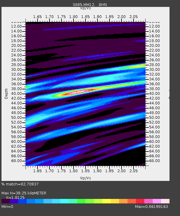
| Estimated Moho Depth: |
39.25 km |
| Estimated Crust Vp/Vs: |
1.81 |
| Assumed Crust Vp: |
6.498 km/s |
| Estimated Crust Vs: |
3.585 km/s |
| Estimated Crust Poisson's Ratio: |
0.28 |
|
| Radial Match: |
82.70937 % |
| Radial Bump: |
383 |
| Transverse Match: |
41.83131 % |
| Transverse Bump: |
400 |
| SOD ConfigId: |
6273 |
| Insert Time: |
2010-02-26 17:52:21.660 +0000 |
| GWidth: |
2.5 |
| Max Bumps: |
400 |
| Tol: |
0.001 |
|

Signal To Noise
| Channel | StoN | STA | LTA |
| XA:MM12: :BHN:19950428T16:41:56.376025Z | 1.488099 | 6.052901E-7 | 4.067539E-7 |
| XA:MM12: :BHE:19950428T16:41:56.376025Z | 2.0954998 | 1.4441702E-6 | 6.8917694E-7 |
| XA:MM12: :BHZ:19950428T16:41:56.376025Z | 7.516806 | 2.5867657E-6 | 3.44131E-7 |
| Arrivals |
| Ps | 5.0 SECOND |
| PpPs | 17 SECOND |
| PsPs/PpSs | 22 SECOND |


