You are here: Home > Network List > CB - China National Seismic Network Stations List
> Station HEH Heihe,Heilongjiang Province > Earthquake Result Viewer
HEH Heihe,Heilongjiang Province - Earthquake Result Viewer

| Earthquake location: |
Tonga Islands |
| Earthquake latitude/longitude: |
-20.6/-173.9 |
| Earthquake time(UTC): |
2017/10/18 (291) 12:00:59 GMT |
| Earthquake Depth: |
10 km |
| Earthquake Magnitude: |
6.0 Mww |
| Earthquake Catalog/Contributor: |
NEIC PDE/us |
|
| Network: |
CB China National Seismic Network |
| Station: |
HEH Heihe,Heilongjiang Province |
| Lat/Lon: |
50.25 N/127.41 E |
| Elevation: |
165 m |
|
| Distance: |
87.5 deg |
| Az: |
326.7 deg |
| Baz: |
126.751 deg |
| Ray Param: |
0.043309785 |
| Estimated Moho Depth: |
29.5 km |
| Estimated Crust Vp/Vs: |
1.89 |
| Assumed Crust Vp: |
6.419 km/s |
| Estimated Crust Vs: |
3.387 km/s |
| Estimated Crust Poisson's Ratio: |
0.31 |
|
| Radial Match: |
95.8687 % |
| Radial Bump: |
322 |
| Transverse Match: |
86.65757 % |
| Transverse Bump: |
358 |
| SOD ConfigId: |
2973751 |
| Insert Time: |
2018-10-09 00:19:50.387 +0000 |
| GWidth: |
2.5 |
| Max Bumps: |
400 |
| Tol: |
0.001 |
|
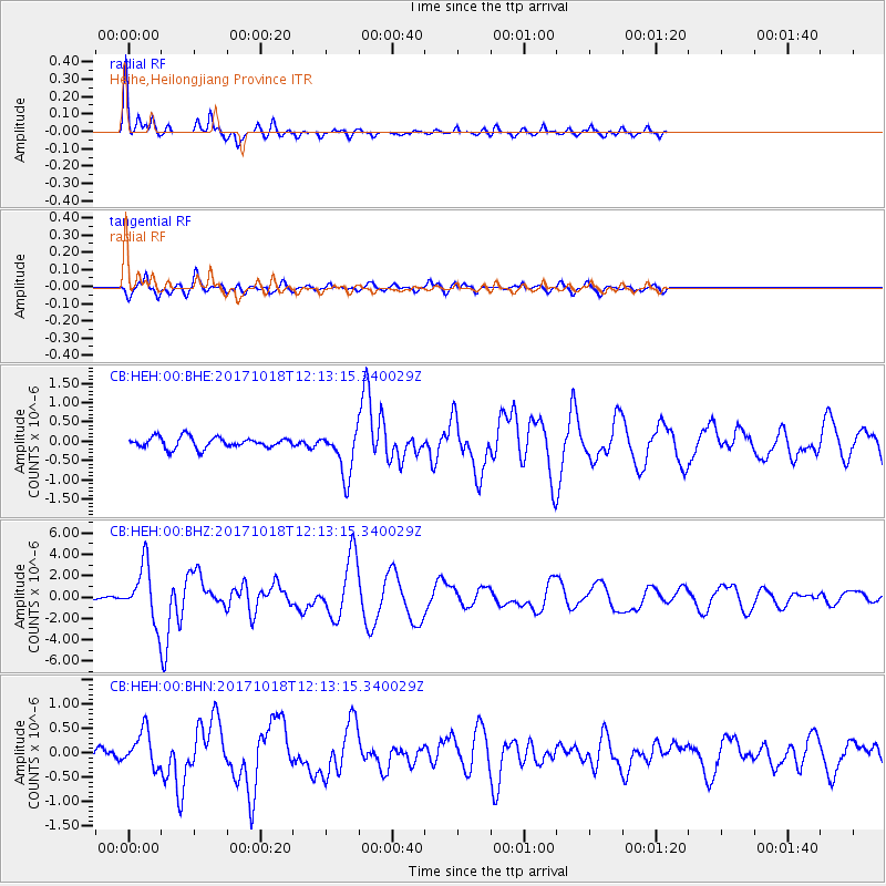
Signal To Noise
| Channel | StoN | STA | LTA |
| CB:HEH:00:BHZ:20171018T12:13:15.340029Z | 34.168163 | 2.699696E-6 | 7.901203E-8 |
| CB:HEH:00:BHN:20171018T12:13:15.340029Z | 3.0083182 | 3.5873109E-7 | 1.192464E-7 |
| CB:HEH:00:BHE:20171018T12:13:15.340029Z | 4.69727 | 6.67899E-7 | 1.4218875E-7 |
| Arrivals |
| Ps | 4.2 SECOND |
| PpPs | 13 SECOND |
| PsPs/PpSs | 17 SECOND |


