You are here: Home > Network List > CB - China National Seismic Network Stations List
> Station LYN Luoyang,Henan Province > Earthquake Result Viewer
LYN Luoyang,Henan Province - Earthquake Result Viewer
| Earthquake location: |
Tonga Islands |
| Earthquake latitude/longitude: |
-20.6/-173.9 |
| Earthquake time(UTC): |
2017/10/18 (291) 12:00:59 GMT |
| Earthquake Depth: |
10 km |
| Earthquake Magnitude: |
6.0 Mww |
| Earthquake Catalog/Contributor: |
NEIC PDE/us |
|
| Network: |
CB China National Seismic Network |
| Station: |
LYN Luoyang,Henan Province |
| Lat/Lon: |
34.55 N/112.47 E |
| Elevation: |
170 m |
|
| Distance: |
88.8 deg |
| Az: |
307.615 deg |
| Baz: |
115.963 deg |
| Ray Param: |
0.04229447 |
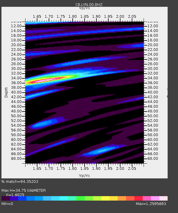
| Estimated Moho Depth: |
34.75 km |
| Estimated Crust Vp/Vs: |
1.68 |
| Assumed Crust Vp: |
6.155 km/s |
| Estimated Crust Vs: |
3.658 km/s |
| Estimated Crust Poisson's Ratio: |
0.23 |
|
| Radial Match: |
94.35203 % |
| Radial Bump: |
371 |
| Transverse Match: |
76.887955 % |
| Transverse Bump: |
400 |
| SOD ConfigId: |
2973751 |
| Insert Time: |
2018-10-09 00:19:53.580 +0000 |
| GWidth: |
2.5 |
| Max Bumps: |
400 |
| Tol: |
0.001 |
|

Signal To Noise
| Channel | StoN | STA | LTA |
| CB:LYN:00:BHZ:20171018T12:13:21.940005Z | 9.883712 | 3.2115906E-6 | 3.249377E-7 |
| CB:LYN:00:BHN:20171018T12:13:21.940005Z | 1.4679738 | 4.3886152E-7 | 2.989573E-7 |
| CB:LYN:00:BHE:20171018T12:13:21.940005Z | 3.0801337 | 8.984393E-7 | 2.916884E-7 |
| Arrivals |
| Ps | 3.9 SECOND |
| PpPs | 15 SECOND |
| PsPs/PpSs | 19 SECOND |


