You are here: Home > Network List > AV - Alaska Volcano Observatory Stations List
> Station ETKA Kagalaska Island, Regional Station, Alaska > Earthquake Result Viewer
ETKA Kagalaska Island, Regional Station, Alaska - Earthquake Result Viewer
| Earthquake location: |
Solomon Islands |
| Earthquake latitude/longitude: |
-9.8/159.6 |
| Earthquake time(UTC): |
2022/11/22 (326) 02:03:07 GMT |
| Earthquake Depth: |
14 km |
| Earthquake Magnitude: |
7.0 Mww |
| Earthquake Catalog/Contributor: |
NEIC PDE/us |
|
| Network: |
AV Alaska Volcano Observatory |
| Station: |
ETKA Kagalaska Island, Regional Station, Alaska |
| Lat/Lon: |
51.86 N/176.41 W |
| Elevation: |
290 m |
|
| Distance: |
64.8 deg |
| Az: |
16.187 deg |
| Baz: |
206.299 deg |
| Ray Param: |
0.058671314 |
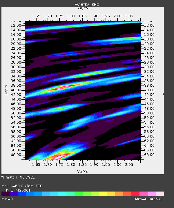
| Estimated Moho Depth: |
69.0 km |
| Estimated Crust Vp/Vs: |
1.74 |
| Assumed Crust Vp: |
5.88 km/s |
| Estimated Crust Vs: |
3.375 km/s |
| Estimated Crust Poisson's Ratio: |
0.25 |
|
| Radial Match: |
90.7921 % |
| Radial Bump: |
400 |
| Transverse Match: |
85.70853 % |
| Transverse Bump: |
400 |
| SOD ConfigId: |
29823551 |
| Insert Time: |
2022-12-06 02:11:50.358 +0000 |
| GWidth: |
2.5 |
| Max Bumps: |
400 |
| Tol: |
0.001 |
|

Signal To Noise
| Channel | StoN | STA | LTA |
| AV:ETKA: :BHZ:20221122T02:13:14.098979Z | 8.740193 | 7.6044034E-6 | 8.700498E-7 |
| AV:ETKA: :BHN:20221122T02:13:14.098979Z | 3.591709 | 4.910892E-6 | 1.3672857E-6 |
| AV:ETKA: :BHE:20221122T02:13:14.098979Z | 1.738776 | 1.956734E-6 | 1.1253514E-6 |
| Arrivals |
| Ps | 9.0 SECOND |
| PpPs | 31 SECOND |
| PsPs/PpSs | 40 SECOND |


