You are here: Home > Network List > AV - Alaska Volcano Observatory Stations List
> Station KIRH Round Head, Kanaga Volcano, Alaska > Earthquake Result Viewer
KIRH Round Head, Kanaga Volcano, Alaska - Earthquake Result Viewer
| Earthquake location: |
Solomon Islands |
| Earthquake latitude/longitude: |
-9.8/159.6 |
| Earthquake time(UTC): |
2022/11/22 (326) 02:03:07 GMT |
| Earthquake Depth: |
14 km |
| Earthquake Magnitude: |
7.0 Mww |
| Earthquake Catalog/Contributor: |
NEIC PDE/us |
|
| Network: |
AV Alaska Volcano Observatory |
| Station: |
KIRH Round Head, Kanaga Volcano, Alaska |
| Lat/Lon: |
51.90 N/177.09 W |
| Elevation: |
321 m |
|
| Distance: |
64.7 deg |
| Az: |
15.746 deg |
| Baz: |
205.572 deg |
| Ray Param: |
0.05877093 |
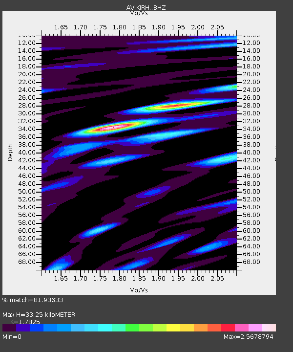
| Estimated Moho Depth: |
33.25 km |
| Estimated Crust Vp/Vs: |
1.78 |
| Assumed Crust Vp: |
5.88 km/s |
| Estimated Crust Vs: |
3.299 km/s |
| Estimated Crust Poisson's Ratio: |
0.27 |
|
| Radial Match: |
81.93633 % |
| Radial Bump: |
400 |
| Transverse Match: |
76.15947 % |
| Transverse Bump: |
400 |
| SOD ConfigId: |
29823551 |
| Insert Time: |
2022-12-06 02:12:45.749 +0000 |
| GWidth: |
2.5 |
| Max Bumps: |
400 |
| Tol: |
0.001 |
|

Signal To Noise
| Channel | StoN | STA | LTA |
| AV:KIRH: :BHZ:20221122T02:13:13.118999Z | 8.1717415 | 9.52728E-6 | 1.1658813E-6 |
| AV:KIRH: :BHN:20221122T02:13:13.118999Z | 1.415132 | 3.7443997E-6 | 2.6459718E-6 |
| AV:KIRH: :BHE:20221122T02:13:13.118999Z | 1.1603796 | 2.3673108E-6 | 2.0401174E-6 |
| Arrivals |
| Ps | 4.6 SECOND |
| PpPs | 15 SECOND |
| PsPs/PpSs | 20 SECOND |


