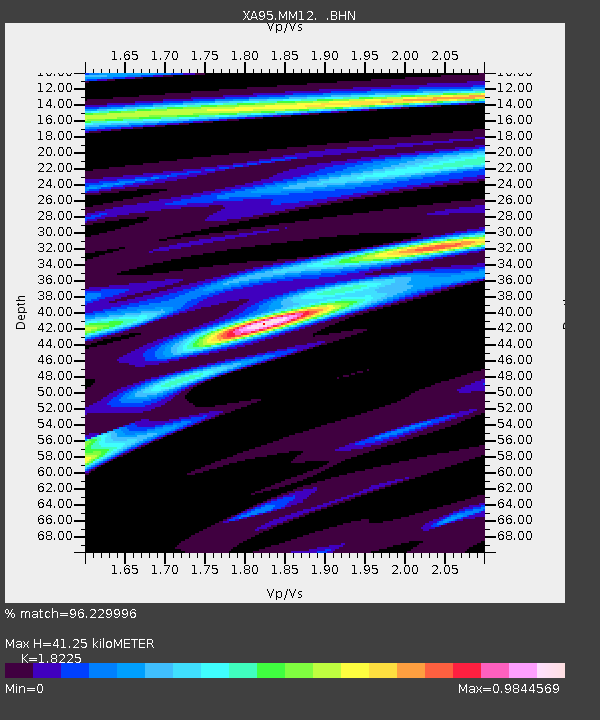
MM12 Laura, Ohio - Earthquake Result Viewer

Earthquake location: Off Coast Of Northern California
Earthquake latitude/longitude: 40.6/-125.5
Earthquake time(UTC): 1995/02/19 (050) 04:03:16 GMT
Earthquake Depth: 10 km
Earthquake Magnitude: 6.1 MB, 6.8 MS, 6.7 UNKNOWN, 6.6 MD
Earthquake Catalog/Contributor: WHDF/NEIC
Network: XA Missouri to Massachusetts Transect
Station: MM12 Laura, Ohio
Lat/Lon: 40.04 N/84.37 W
Elevation: 305 m
Distance: 31.2 deg
Az: 77.3 deg
Baz: 284.495 deg
Ray Param: 0.079134636
Estimated Moho Depth: 41.25 km
Estimated Crust Vp/Vs: 1.82
Assumed Crust Vp: 6.498 km/s
Estimated Crust Vs: 3.565 km/s
Estimated Crust Poisson's Ratio: 0.28
Radial Match: 96.229996 %
Radial Bump: 251
Transverse Match: 82.32443 %
Transverse Bump: 400
SOD ConfigId: 6273
Insert Time: 2010-02-26 17:52:25.141 +0000
GWidth: 2.5
Max Bumps: 400
Tol: 0.001

Signal To Noise

ChannelStoNSTALTA
XA:MM12: :BHN:19950219T04:09:04.736011Z3.95111086.2654345E-71.58574E-7
XA:MM12: :BHE:19950219T04:09:04.736011Z13.2595831.7372458E-61.3101813E-7
XA:MM12: :BHZ:19950219T04:09:04.736011Z15.471922.8867605E-61.8658062E-7
Arrivals
Ps5.7 SECOND
PpPs17 SECOND
PsPs/PpSs22 SECOND