You are here: Home > Network List > CC - Cascade Chain Volcano Monitoring Stations List
> Station LOO Loowit > Earthquake Result Viewer
LOO Loowit - Earthquake Result Viewer
| Earthquake location: |
Solomon Islands |
| Earthquake latitude/longitude: |
-9.8/159.6 |
| Earthquake time(UTC): |
2022/11/22 (326) 02:03:07 GMT |
| Earthquake Depth: |
14 km |
| Earthquake Magnitude: |
7.0 Mww |
| Earthquake Catalog/Contributor: |
NEIC PDE/us |
|
| Network: |
CC Cascade Chain Volcano Monitoring |
| Station: |
LOO Loowit |
| Lat/Lon: |
46.22 N/122.18 W |
| Elevation: |
1521 m |
|
| Distance: |
89.0 deg |
| Az: |
42.826 deg |
| Baz: |
254.794 deg |
| Ray Param: |
0.04218079 |
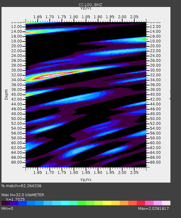
| Estimated Moho Depth: |
32.0 km |
| Estimated Crust Vp/Vs: |
1.70 |
| Assumed Crust Vp: |
6.566 km/s |
| Estimated Crust Vs: |
3.857 km/s |
| Estimated Crust Poisson's Ratio: |
0.24 |
|
| Radial Match: |
92.264336 % |
| Radial Bump: |
400 |
| Transverse Match: |
88.168976 % |
| Transverse Bump: |
400 |
| SOD ConfigId: |
29823551 |
| Insert Time: |
2022-12-06 02:17:02.102 +0000 |
| GWidth: |
2.5 |
| Max Bumps: |
400 |
| Tol: |
0.001 |
|

Signal To Noise
| Channel | StoN | STA | LTA |
| CC:LOO: :BHZ:20221122T02:15:29.660014Z | 7.8487606 | 1.6920451E-6 | 2.1558118E-7 |
| CC:LOO: :BHN:20221122T02:15:29.660014Z | 1.788268 | 4.131252E-7 | 2.3101975E-7 |
| CC:LOO: :BHE:20221122T02:15:29.660014Z | 0.6133542 | 3.0301365E-7 | 4.9402723E-7 |
| Arrivals |
| Ps | 3.5 SECOND |
| PpPs | 13 SECOND |
| PsPs/PpSs | 16 SECOND |


