You are here: Home > Network List > CI - Caltech Regional Seismic Network Stations List
> Station TUQ Turquiose Mountain, Baker, CA, USA > Earthquake Result Viewer
TUQ Turquiose Mountain, Baker, CA, USA - Earthquake Result Viewer
| Earthquake location: |
Solomon Islands |
| Earthquake latitude/longitude: |
-9.8/159.6 |
| Earthquake time(UTC): |
2022/11/22 (326) 02:03:07 GMT |
| Earthquake Depth: |
14 km |
| Earthquake Magnitude: |
7.0 Mww |
| Earthquake Catalog/Contributor: |
NEIC PDE/us |
|
| Network: |
CI Caltech Regional Seismic Network |
| Station: |
TUQ Turquiose Mountain, Baker, CA, USA |
| Lat/Lon: |
35.44 N/115.92 W |
| Elevation: |
1350 m |
|
| Distance: |
91.2 deg |
| Az: |
54.389 deg |
| Baz: |
258.877 deg |
| Ray Param: |
0.041637767 |
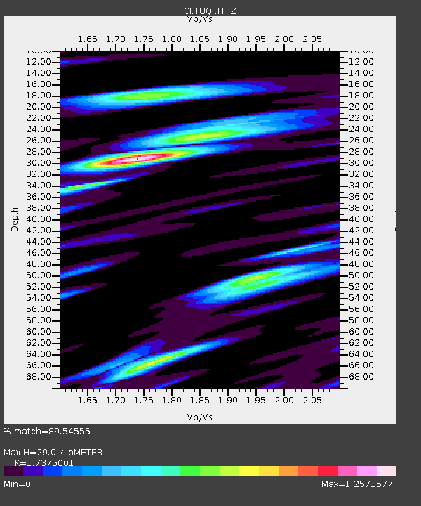
| Estimated Moho Depth: |
29.0 km |
| Estimated Crust Vp/Vs: |
1.74 |
| Assumed Crust Vp: |
6.276 km/s |
| Estimated Crust Vs: |
3.612 km/s |
| Estimated Crust Poisson's Ratio: |
0.25 |
|
| Radial Match: |
89.54555 % |
| Radial Bump: |
400 |
| Transverse Match: |
80.61064 % |
| Transverse Bump: |
400 |
| SOD ConfigId: |
29823551 |
| Insert Time: |
2022-12-06 02:20:22.414 +0000 |
| GWidth: |
2.5 |
| Max Bumps: |
400 |
| Tol: |
0.001 |
|
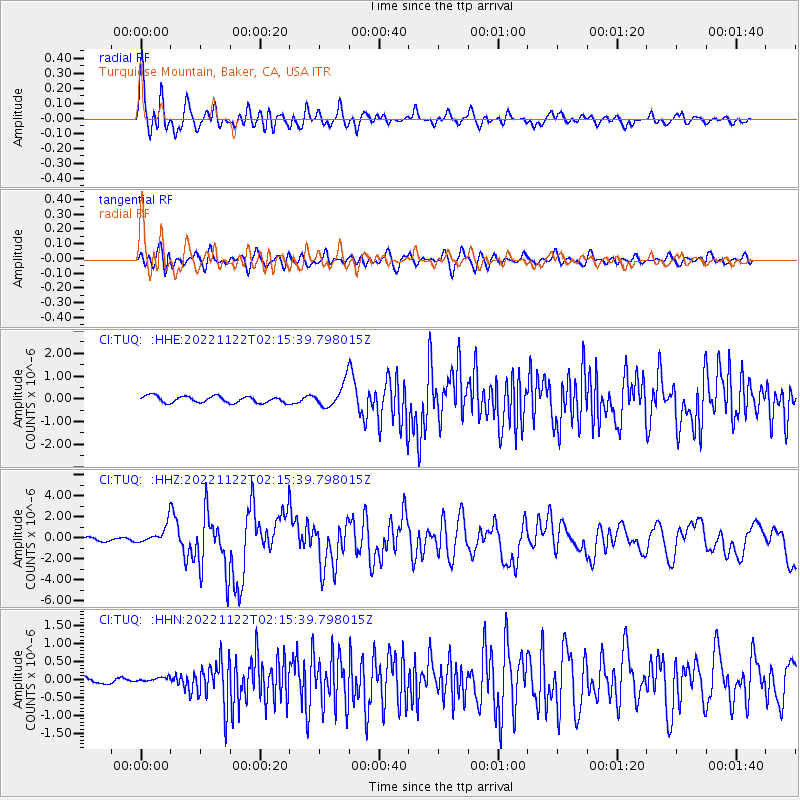
Signal To Noise
| Channel | StoN | STA | LTA |
| CI:TUQ: :HHZ:20221122T02:15:39.798015Z | 4.746806 | 9.208427E-7 | 1.9399205E-7 |
| CI:TUQ: :HHN:20221122T02:15:39.798015Z | 0.48321024 | 8.197698E-8 | 1.6965075E-7 |
| CI:TUQ: :HHE:20221122T02:15:39.798015Z | 3.6156158 | 5.2131423E-7 | 1.4418409E-7 |
| Arrivals |
| Ps | 3.5 SECOND |
| PpPs | 12 SECOND |
| PsPs/PpSs | 16 SECOND |


