You are here: Home > Network List > IU - Global Seismograph Network (GSN - IRIS/USGS) Stations List
> Station ANTO Ankara, Turkey > Earthquake Result Viewer
ANTO Ankara, Turkey - Earthquake Result Viewer
| Earthquake location: |
Myanmar-India Border Region |
| Earthquake latitude/longitude: |
24.3/94.7 |
| Earthquake time(UTC): |
2009/09/03 (246) 19:51:08 GMT |
| Earthquake Depth: |
105 km |
| Earthquake Magnitude: |
5.7 MB, 5.9 MW, 5.8 MW |
| Earthquake Catalog/Contributor: |
WHDF/NEIC |
|
| Network: |
IU Global Seismograph Network (GSN - IRIS/USGS) |
| Station: |
ANTO Ankara, Turkey |
| Lat/Lon: |
39.87 N/32.79 E |
| Elevation: |
1090 m |
|
| Distance: |
53.7 deg |
| Az: |
302.584 deg |
| Baz: |
87.091 deg |
| Ray Param: |
0.065611735 |
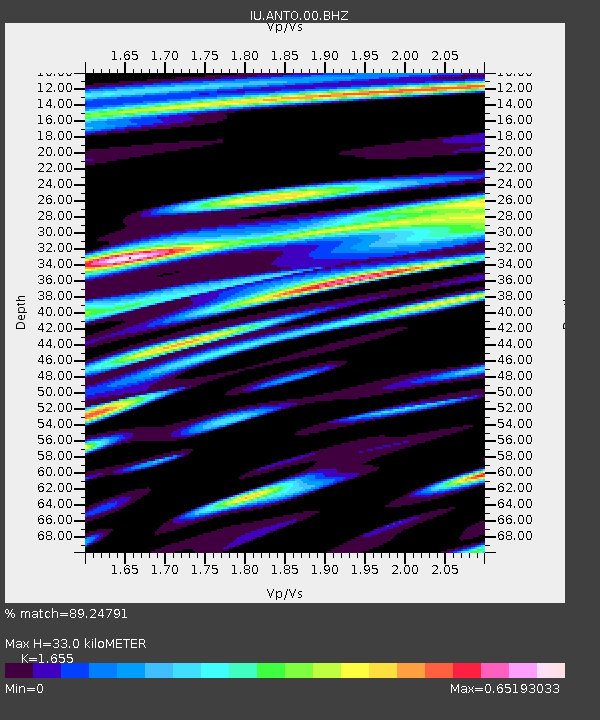
| Estimated Moho Depth: |
33.0 km |
| Estimated Crust Vp/Vs: |
1.65 |
| Assumed Crust Vp: |
6.159 km/s |
| Estimated Crust Vs: |
3.721 km/s |
| Estimated Crust Poisson's Ratio: |
0.21 |
|
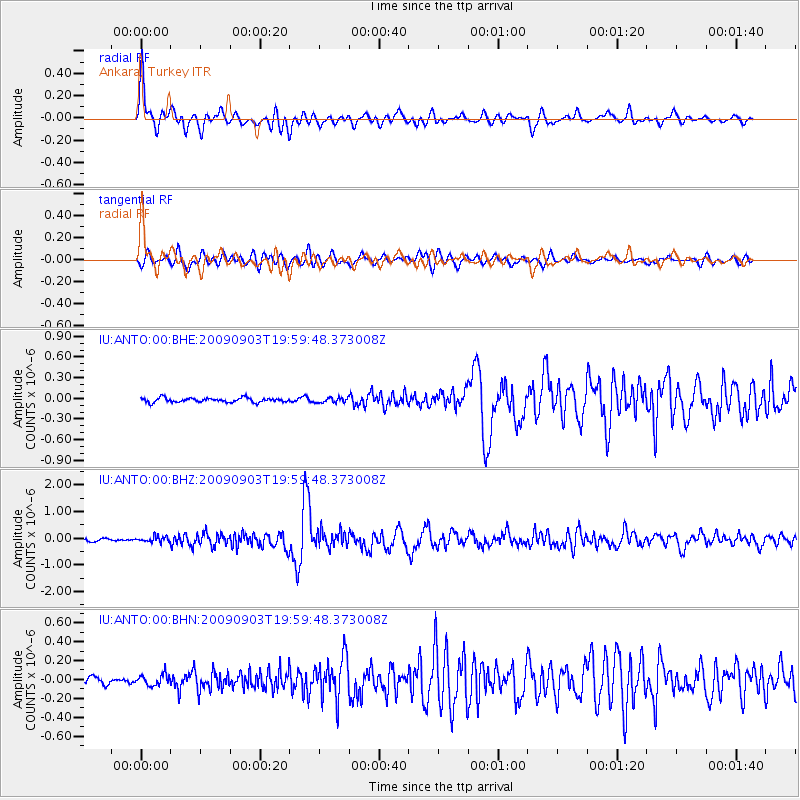
| Radial Match: |
89.24791 % |
| Radial Bump: |
400 |
| Transverse Match: |
77.09063 % |
| Transverse Bump: |
400 |
| SOD ConfigId: |
1 |
| Insert Time: |
2010-02-19 00:08:27.619 +0000 |
| GWidth: |
2.5 |
| Max Bumps: |
400 |
| Tol: |
0.001 |
|
Signal To Noise
| Channel | StoN | STA | LTA |
| IU:ANTO:00:BHZ:20090903T19:59:48.373008Z | 2.271917 | 1.06618515E-7 | 4.6928875E-8 |
| IU:ANTO:00:BHN:20090903T19:59:48.373008Z | 1.9622394 | 5.9179644E-8 | 3.015924E-8 |
| IU:ANTO:00:BHE:20090903T19:59:48.373008Z | 1.1658446 | 3.6078553E-8 | 3.0946282E-8 |
| Arrivals |
| Ps | 3.7 SECOND |
| PpPs | 14 SECOND |
| PsPs/PpSs | 17 SECOND |


