You are here: Home > Network List > CN - Canadian National Seismograph Network Stations List
> Station PABB Port Alberni, BC, CA > Earthquake Result Viewer
PABB Port Alberni, BC, CA - Earthquake Result Viewer
| Earthquake location: |
Solomon Islands |
| Earthquake latitude/longitude: |
-9.8/159.6 |
| Earthquake time(UTC): |
2022/11/22 (326) 02:03:07 GMT |
| Earthquake Depth: |
14 km |
| Earthquake Magnitude: |
7.0 Mww |
| Earthquake Catalog/Contributor: |
NEIC PDE/us |
|
| Network: |
CN Canadian National Seismograph Network |
| Station: |
PABB Port Alberni, BC, CA |
| Lat/Lon: |
49.22 N/124.81 W |
| Elevation: |
3.0 m |
|
| Distance: |
88.1 deg |
| Az: |
39.452 deg |
| Baz: |
252.77 deg |
| Ray Param: |
0.042821426 |
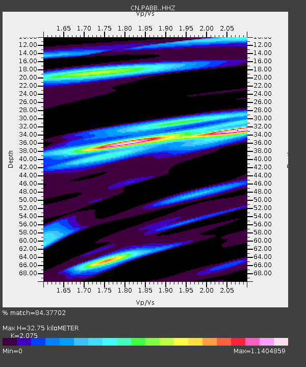
| Estimated Moho Depth: |
32.75 km |
| Estimated Crust Vp/Vs: |
2.08 |
| Assumed Crust Vp: |
6.391 km/s |
| Estimated Crust Vs: |
3.08 km/s |
| Estimated Crust Poisson's Ratio: |
0.35 |
|
| Radial Match: |
84.37702 % |
| Radial Bump: |
330 |
| Transverse Match: |
78.17576 % |
| Transverse Bump: |
400 |
| SOD ConfigId: |
29823551 |
| Insert Time: |
2022-12-06 02:21:25.995 +0000 |
| GWidth: |
2.5 |
| Max Bumps: |
400 |
| Tol: |
0.001 |
|

Signal To Noise
| Channel | StoN | STA | LTA |
| CN:PABB: :HHZ:20221122T02:15:25.569987Z | 2.9690983 | 1.7035695E-6 | 5.737666E-7 |
| CN:PABB: :HHN:20221122T02:15:25.569987Z | 0.94402695 | 2.926653E-7 | 3.1001798E-7 |
| CN:PABB: :HHE:20221122T02:15:25.569987Z | 1.4577464 | 5.8523744E-7 | 4.0146722E-7 |
| Arrivals |
| Ps | 5.6 SECOND |
| PpPs | 15 SECOND |
| PsPs/PpSs | 21 SECOND |


