You are here: Home > Network List > CN - Canadian National Seismograph Network Stations List
> Station PTRF Port Renfrew PTRF, BC, CA > Earthquake Result Viewer
PTRF Port Renfrew PTRF, BC, CA - Earthquake Result Viewer
| Earthquake location: |
Solomon Islands |
| Earthquake latitude/longitude: |
-9.8/159.6 |
| Earthquake time(UTC): |
2022/11/22 (326) 02:03:07 GMT |
| Earthquake Depth: |
14 km |
| Earthquake Magnitude: |
7.0 Mww |
| Earthquake Catalog/Contributor: |
NEIC PDE/us |
|
| Network: |
CN Canadian National Seismograph Network |
| Station: |
PTRF Port Renfrew PTRF, BC, CA |
| Lat/Lon: |
48.54 N/124.41 W |
| Elevation: |
164 m |
|
| Distance: |
88.2 deg |
| Az: |
40.175 deg |
| Baz: |
253.093 deg |
| Ray Param: |
0.04278178 |
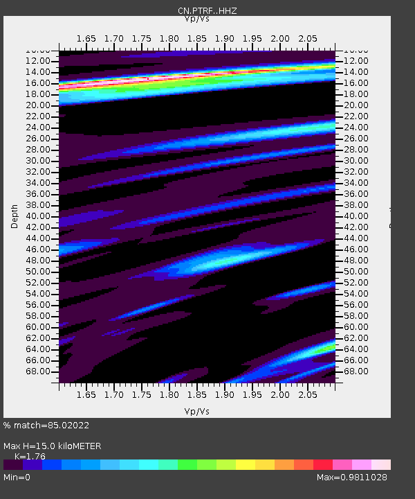
| Estimated Moho Depth: |
15.0 km |
| Estimated Crust Vp/Vs: |
1.76 |
| Assumed Crust Vp: |
6.391 km/s |
| Estimated Crust Vs: |
3.631 km/s |
| Estimated Crust Poisson's Ratio: |
0.26 |
|
| Radial Match: |
85.02022 % |
| Radial Bump: |
325 |
| Transverse Match: |
74.83138 % |
| Transverse Bump: |
400 |
| SOD ConfigId: |
29823551 |
| Insert Time: |
2022-12-06 02:21:37.400 +0000 |
| GWidth: |
2.5 |
| Max Bumps: |
400 |
| Tol: |
0.001 |
|

Signal To Noise
| Channel | StoN | STA | LTA |
| CN:PTRF: :HHZ:20221122T02:15:25.819987Z | 6.7953587 | 2.2271954E-6 | 3.2775247E-7 |
| CN:PTRF: :HHN:20221122T02:15:25.819987Z | 1.0420579 | 2.4050618E-7 | 2.3079926E-7 |
| CN:PTRF: :HHE:20221122T02:15:25.819987Z | 2.2676978 | 6.7670834E-7 | 2.9841203E-7 |
| Arrivals |
| Ps | 1.8 SECOND |
| PpPs | 6.3 SECOND |
| PsPs/PpSs | 8.2 SECOND |


