You are here: Home > Network List > XA95 - Missouri to Massachusetts Transect Stations List
> Station MM12 Laura, Ohio > Earthquake Result Viewer
MM12 Laura, Ohio - Earthquake Result Viewer
| Earthquake location: |
Kuril Islands |
| Earthquake latitude/longitude: |
45.3/149.9 |
| Earthquake time(UTC): |
1996/02/07 (038) 21:36:45 GMT |
| Earthquake Depth: |
33 km |
| Earthquake Magnitude: |
6.3 MB, 7.0 MS, 7.2 UNKNOWN, 7.1 MW |
| Earthquake Catalog/Contributor: |
WHDF/NEIC |
|
| Network: |
XA Missouri to Massachusetts Transect |
| Station: |
MM12 Laura, Ohio |
| Lat/Lon: |
40.04 N/84.37 W |
| Elevation: |
305 m |
|
| Distance: |
82.1 deg |
| Az: |
38.998 deg |
| Baz: |
324.666 deg |
| Ray Param: |
0.04709833 |
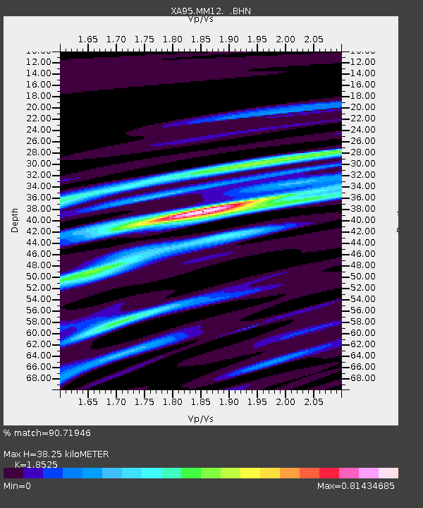
| Estimated Moho Depth: |
38.25 km |
| Estimated Crust Vp/Vs: |
1.85 |
| Assumed Crust Vp: |
6.498 km/s |
| Estimated Crust Vs: |
3.507 km/s |
| Estimated Crust Poisson's Ratio: |
0.29 |
|
| Radial Match: |
90.71946 % |
| Radial Bump: |
400 |
| Transverse Match: |
65.432175 % |
| Transverse Bump: |
400 |
| SOD ConfigId: |
6273 |
| Insert Time: |
2010-02-26 17:52:33.223 +0000 |
| GWidth: |
2.5 |
| Max Bumps: |
400 |
| Tol: |
0.001 |
|

Signal To Noise
| Channel | StoN | STA | LTA |
| XA:MM12: :BHN:19960207T21:48:31.024011Z | 0.47444266 | 4.4961425E-7 | 9.476683E-7 |
| XA:MM12: :BHE:19960207T21:48:31.024011Z | 1.0212581 | 1.0384654E-6 | 1.0168491E-6 |
| XA:MM12: :BHZ:19960207T21:48:31.024011Z | 2.2441895 | 2.092878E-6 | 9.325763E-7 |
| Arrivals |
| Ps | 5.2 SECOND |
| PpPs | 16 SECOND |
| PsPs/PpSs | 22 SECOND |


