You are here: Home > Network List > IC - New China Digital Seismograph Network Stations List
> Station KMI Kunming, Yunnan Province, China > Earthquake Result Viewer
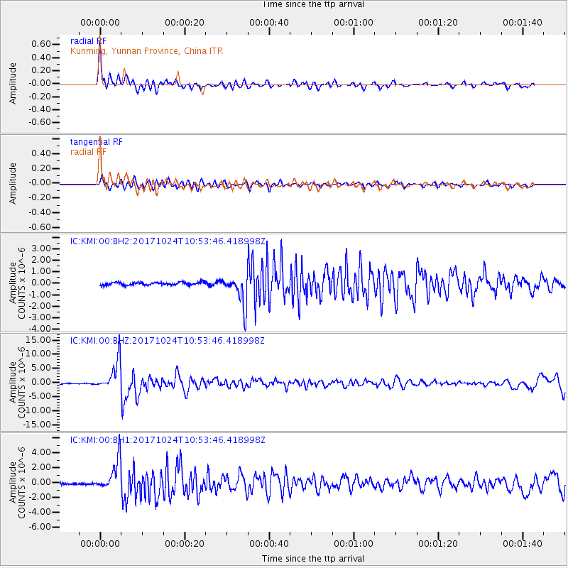
KMI Kunming, Yunnan Province, China - Earthquake Result Viewer
*The percent match for this event was below the threshold and hence no stack was calculated.
| Earthquake location: |
Banda Sea |
| Earthquake latitude/longitude: |
-7.2/123.0 |
| Earthquake time(UTC): |
2017/10/24 (297) 10:47:47 GMT |
| Earthquake Depth: |
549 km |
| Earthquake Magnitude: |
6.7 Mww |
| Earthquake Catalog/Contributor: |
NEIC PDE/us |
|
| Network: |
IC New China Digital Seismograph Network |
| Station: |
KMI Kunming, Yunnan Province, China |
| Lat/Lon: |
25.12 N/102.74 E |
| Elevation: |
1975 m |
|
| Distance: |
37.8 deg |
| Az: |
329.091 deg |
| Baz: |
145.791 deg |
| Ray Param: |
$rayparam |
*The percent match for this event was below the threshold and hence was not used in the summary stack. |
|
| Radial Match: |
79.37547 % |
| Radial Bump: |
400 |
| Transverse Match: |
65.28734 % |
| Transverse Bump: |
400 |
| SOD ConfigId: |
2973751 |
| Insert Time: |
2018-10-09 00:31:11.773 +0000 |
| GWidth: |
2.5 |
| Max Bumps: |
400 |
| Tol: |
0.001 |
|
Signal To Noise
| Channel | StoN | STA | LTA |
| IC:KMI:00:BHZ:20171024T10:53:46.418998Z | 44.32181 | 5.5802093E-6 | 1.259021E-7 |
| IC:KMI:00:BH1:20171024T10:53:46.418998Z | 22.729744 | 2.160158E-6 | 9.503661E-8 |
| IC:KMI:00:BH2:20171024T10:53:46.418998Z | 11.312808 | 1.3850992E-6 | 1.2243636E-7 |
| Arrivals |
| Ps | |
| PpPs | |
| PsPs/PpSs | |


