You are here: Home > Network List > US - United States National Seismic Network Stations List
> Station MNTX Cornudas Mountains, Texas, USA > Earthquake Result Viewer
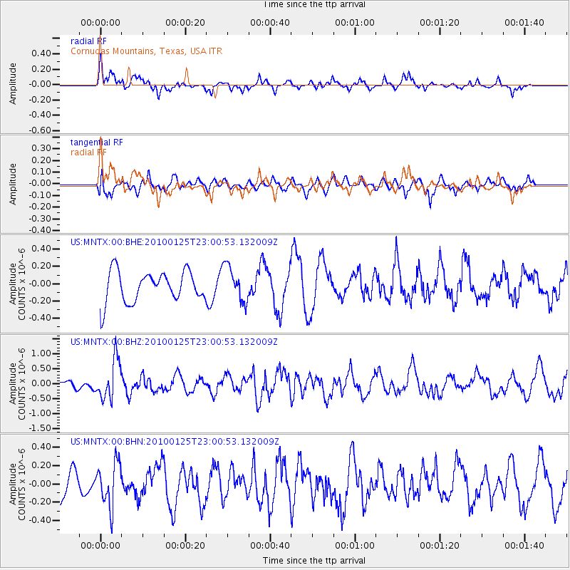
MNTX Cornudas Mountains, Texas, USA - Earthquake Result Viewer
*The percent match for this event was below the threshold and hence no stack was calculated.
| Earthquake location: |
Peru-Brazil Border Region |
| Earthquake latitude/longitude: |
-8.5/-74.5 |
| Earthquake time(UTC): |
2010/01/25 (025) 22:52:46 GMT |
| Earthquake Depth: |
147 km |
| Earthquake Magnitude: |
5.7 MB, 5.9 MW, 5.9 MW |
| Earthquake Catalog/Contributor: |
WHDF/NEIC |
|
| Network: |
US United States National Seismic Network |
| Station: |
MNTX Cornudas Mountains, Texas, USA |
| Lat/Lon: |
31.70 N/105.38 W |
| Elevation: |
404 m |
|
| Distance: |
49.7 deg |
| Az: |
324.963 deg |
| Baz: |
138.224 deg |
| Ray Param: |
$rayparam |
*The percent match for this event was below the threshold and hence was not used in the summary stack. |
|
| Radial Match: |
62.626656 % |
| Radial Bump: |
391 |
| Transverse Match: |
66.52217 % |
| Transverse Bump: |
400 |
| SOD ConfigId: |
296938 |
| Insert Time: |
2010-04-06 23:53:18.871 +0000 |
| GWidth: |
2.5 |
| Max Bumps: |
400 |
| Tol: |
0.001 |
|
Signal To Noise
| Channel | StoN | STA | LTA |
| US:MNTX:00:BHZ:20100125T23:00:53.132009Z | 3.4418201 | 6.682013E-7 | 1.9414185E-7 |
| US:MNTX:00:BHN:20100125T23:00:53.132009Z | 0.7977961 | 2.4288786E-7 | 3.0444855E-7 |
| US:MNTX:00:BHE:20100125T23:00:53.132009Z | 1.1381996 | 2.0169058E-7 | 1.7720141E-7 |
| Arrivals |
| Ps | |
| PpPs | |
| PsPs/PpSs | |


