MM12 Laura, Ohio - Earthquake Result Viewer
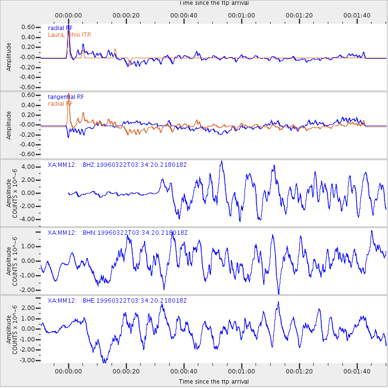
Earthquake location: Rat Islands, Aleutian Islands
Earthquake latitude/longitude: 51.2/178.7
Earthquake time(UTC): 1996/03/22 (082) 03:24:20 GMT
Earthquake Depth: 20 km
Earthquake Magnitude: 5.7 MB, 6.6 MS, 6.8 UNKNOWN, 6.6 ML
Earthquake Catalog/Contributor: WHDF/NEIC
Network: XA Missouri to Massachusetts Transect
Station: MM12 Laura, Ohio
Lat/Lon: 40.04 N/84.37 W
Elevation: 305 m
Distance: 63.9 deg
Az: 58.062 deg
Baz: 315.958 deg
Ray Param: 0.059254754
Estimated Moho Depth: 38.0 km
Estimated Crust Vp/Vs: 1.84
Assumed Crust Vp: 6.498 km/s
Estimated Crust Vs: 3.536 km/s
Estimated Crust Poisson's Ratio: 0.29
Radial Match: 86.375694 %
Radial Bump: 400
Transverse Match: 38.62646 %
Transverse Bump: 400
SOD ConfigId: 6273
Insert Time: 2010-02-26 17:52:34.759 +0000
GWidth: 2.5
Max Bumps: 400
Tol: 0.001

Signal To Noise

ChannelStoNSTALTA
XA:MM12: :BHN:19960322T03:34:20.218018Z0.732827967.4302824E-71.013919E-6
XA:MM12: :BHE:19960322T03:34:20.218018Z0.372142943.997048E-71.0740625E-6
XA:MM12: :BHZ:19960322T03:34:20.218018Z5.4603461.0515434E-61.9257817E-7
Arrivals
Ps5.1 SECOND
PpPs16 SECOND
PsPs/PpSs21 SECOND