You are here: Home > Network List > UO - University of Oregon Regional Network Stations List
> Station TOOM Fort Rock, OR, USA > Earthquake Result Viewer
TOOM Fort Rock, OR, USA - Earthquake Result Viewer
| Earthquake location: |
Solomon Islands |
| Earthquake latitude/longitude: |
-9.8/159.6 |
| Earthquake time(UTC): |
2022/11/22 (326) 02:03:07 GMT |
| Earthquake Depth: |
14 km |
| Earthquake Magnitude: |
7.0 Mww |
| Earthquake Catalog/Contributor: |
NEIC PDE/us |
|
| Network: |
UO University of Oregon Regional Network |
| Station: |
TOOM Fort Rock, OR, USA |
| Lat/Lon: |
43.28 N/121.23 W |
| Elevation: |
1541 m |
|
| Distance: |
88.9 deg |
| Az: |
45.84 deg |
| Baz: |
255.517 deg |
| Ray Param: |
0.042249847 |
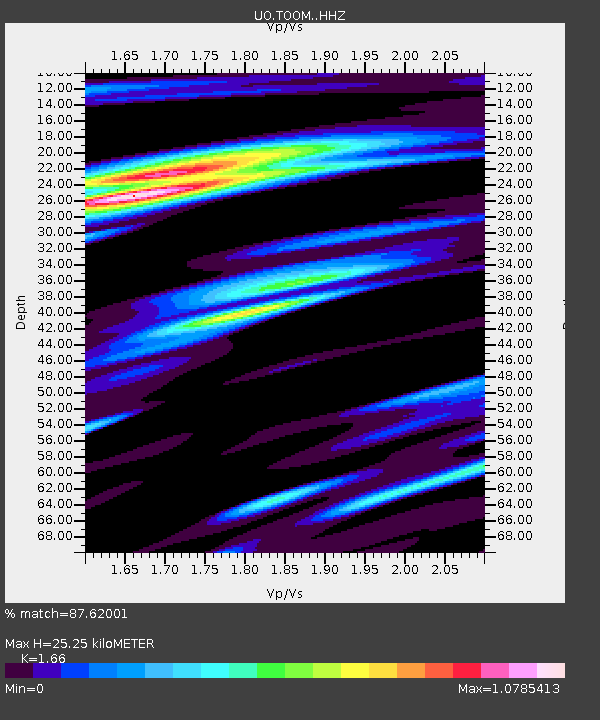
| Estimated Moho Depth: |
25.25 km |
| Estimated Crust Vp/Vs: |
1.66 |
| Assumed Crust Vp: |
6.597 km/s |
| Estimated Crust Vs: |
3.974 km/s |
| Estimated Crust Poisson's Ratio: |
0.22 |
|
| Radial Match: |
87.62001 % |
| Radial Bump: |
388 |
| Transverse Match: |
66.70619 % |
| Transverse Bump: |
400 |
| SOD ConfigId: |
29823551 |
| Insert Time: |
2022-12-06 02:32:11.782 +0000 |
| GWidth: |
2.5 |
| Max Bumps: |
400 |
| Tol: |
0.001 |
|

Signal To Noise
| Channel | StoN | STA | LTA |
| UO:TOOM: :HHZ:20221122T02:15:29.189982Z | 5.5331774 | 1.3840112E-6 | 2.5012955E-7 |
| UO:TOOM: :HHN:20221122T02:15:29.189982Z | 1.1269238 | 3.5474196E-7 | 3.147879E-7 |
| UO:TOOM: :HHE:20221122T02:15:29.189982Z | 0.6120258 | 3.4229333E-7 | 5.592793E-7 |
| Arrivals |
| Ps | 2.6 SECOND |
| PpPs | 9.9 SECOND |
| PsPs/PpSs | 13 SECOND |


