You are here: Home > Network List > UO - University of Oregon Regional Network Stations List
> Station VERN Vernonia Municipal Airport, Vernonia, OR, USA > Earthquake Result Viewer
VERN Vernonia Municipal Airport, Vernonia, OR, USA - Earthquake Result Viewer
| Earthquake location: |
Solomon Islands |
| Earthquake latitude/longitude: |
-9.8/159.6 |
| Earthquake time(UTC): |
2022/11/22 (326) 02:03:07 GMT |
| Earthquake Depth: |
14 km |
| Earthquake Magnitude: |
7.0 Mww |
| Earthquake Catalog/Contributor: |
NEIC PDE/us |
|
| Network: |
UO University of Oregon Regional Network |
| Station: |
VERN Vernonia Municipal Airport, Vernonia, OR, USA |
| Lat/Lon: |
45.85 N/123.25 W |
| Elevation: |
198 m |
|
| Distance: |
88.2 deg |
| Az: |
42.984 deg |
| Baz: |
254.035 deg |
| Ray Param: |
0.042781312 |
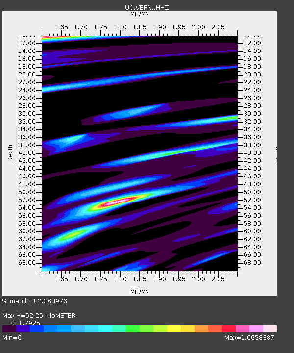
| Estimated Moho Depth: |
52.25 km |
| Estimated Crust Vp/Vs: |
1.79 |
| Assumed Crust Vp: |
6.566 km/s |
| Estimated Crust Vs: |
3.663 km/s |
| Estimated Crust Poisson's Ratio: |
0.27 |
|
| Radial Match: |
82.363976 % |
| Radial Bump: |
382 |
| Transverse Match: |
79.29414 % |
| Transverse Bump: |
400 |
| SOD ConfigId: |
29823551 |
| Insert Time: |
2022-12-06 02:32:19.246 +0000 |
| GWidth: |
2.5 |
| Max Bumps: |
400 |
| Tol: |
0.001 |
|

Signal To Noise
| Channel | StoN | STA | LTA |
| UO:VERN: :HHZ:20221122T02:15:25.819987Z | 10.209362 | 2.1345995E-6 | 2.0908256E-7 |
| UO:VERN: :HHN:20221122T02:15:25.819987Z | 1.5325483 | 8.0144406E-7 | 5.2294865E-7 |
| UO:VERN: :HHE:20221122T02:15:25.819987Z | 1.2091023 | 5.9179575E-7 | 4.8945054E-7 |
| Arrivals |
| Ps | 6.5 SECOND |
| PpPs | 22 SECOND |
| PsPs/PpSs | 28 SECOND |


