You are here: Home > Network List > US - United States National Seismic Network Stations List
> Station BRAL Brewton, Alabama, USA > Earthquake Result Viewer
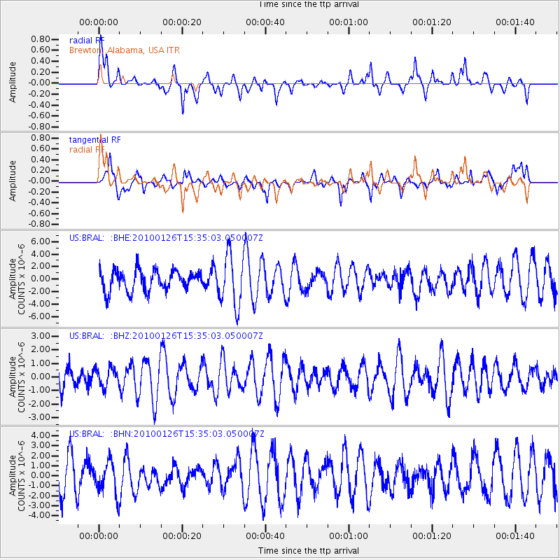
BRAL Brewton, Alabama, USA - Earthquake Result Viewer
*The percent match for this event was below the threshold and hence no stack was calculated.
| Earthquake location: |
Tristan Da Cunha Region |
| Earthquake latitude/longitude: |
-39.3/-15.9 |
| Earthquake time(UTC): |
2010/01/26 (026) 15:22:06 GMT |
| Earthquake Depth: |
10 km |
| Earthquake Magnitude: |
5.7 MB, 5.0 MS |
| Earthquake Catalog/Contributor: |
WHDF/NEIC |
|
| Network: |
US United States National Seismic Network |
| Station: |
BRAL Brewton, Alabama, USA |
| Lat/Lon: |
31.01 N/87.06 W |
| Elevation: |
61 m |
|
| Distance: |
96.2 deg |
| Az: |
305.181 deg |
| Baz: |
132.346 deg |
| Ray Param: |
$rayparam |
*The percent match for this event was below the threshold and hence was not used in the summary stack. |
|
| Radial Match: |
71.44605 % |
| Radial Bump: |
385 |
| Transverse Match: |
39.94795 % |
| Transverse Bump: |
400 |
| SOD ConfigId: |
296938 |
| Insert Time: |
2010-04-06 23:57:06.391 +0000 |
| GWidth: |
2.5 |
| Max Bumps: |
400 |
| Tol: |
0.001 |
|
Signal To Noise
| Channel | StoN | STA | LTA |
| US:BRAL: :BHZ:20100126T15:35:03.050007Z | 0.6176599 | 6.671063E-7 | 1.0800543E-6 |
| US:BRAL: :BHN:20100126T15:35:03.050007Z | 1.0224392 | 1.7063368E-6 | 1.6688882E-6 |
| US:BRAL: :BHE:20100126T15:35:03.050007Z | 2.5144618 | 4.137449E-6 | 1.6454612E-6 |
| Arrivals |
| Ps | |
| PpPs | |
| PsPs/PpSs | |


