You are here: Home > Network List > UW - Pacific Northwest Regional Seismic Network Stations List
> Station LON Longmire CREST broad-band > Earthquake Result Viewer
LON Longmire CREST broad-band - Earthquake Result Viewer
| Earthquake location: |
Solomon Islands |
| Earthquake latitude/longitude: |
-9.8/159.6 |
| Earthquake time(UTC): |
2022/11/22 (326) 02:03:07 GMT |
| Earthquake Depth: |
14 km |
| Earthquake Magnitude: |
7.0 Mww |
| Earthquake Catalog/Contributor: |
NEIC PDE/us |
|
| Network: |
UW Pacific Northwest Regional Seismic Network |
| Station: |
LON Longmire CREST broad-band |
| Lat/Lon: |
46.75 N/121.81 W |
| Elevation: |
853 m |
|
| Distance: |
89.4 deg |
| Az: |
42.384 deg |
| Baz: |
255.059 deg |
| Ray Param: |
0.041896675 |
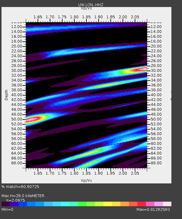
| Estimated Moho Depth: |
29.0 km |
| Estimated Crust Vp/Vs: |
2.10 |
| Assumed Crust Vp: |
6.597 km/s |
| Estimated Crust Vs: |
3.145 km/s |
| Estimated Crust Poisson's Ratio: |
0.35 |
|
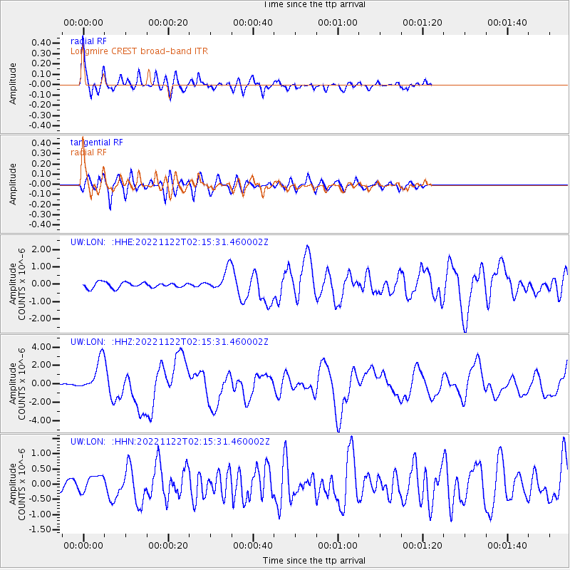
| Radial Match: |
90.90725 % |
| Radial Bump: |
400 |
| Transverse Match: |
79.468636 % |
| Transverse Bump: |
400 |
| SOD ConfigId: |
29823551 |
| Insert Time: |
2022-12-06 02:35:42.584 +0000 |
| GWidth: |
2.5 |
| Max Bumps: |
400 |
| Tol: |
0.001 |
|
Signal To Noise
| Channel | StoN | STA | LTA |
| UW:LON: :HHZ:20221122T02:15:31.460002Z | 8.956724 | 1.8280514E-6 | 2.0409821E-7 |
| UW:LON: :HHN:20221122T02:15:31.460002Z | 1.8577411 | 2.7721083E-7 | 1.492193E-7 |
| UW:LON: :HHE:20221122T02:15:31.460002Z | 4.0516405 | 6.4006747E-7 | 1.5797735E-7 |
| Arrivals |
| Ps | 4.9 SECOND |
| PpPs | 13 SECOND |
| PsPs/PpSs | 18 SECOND |


