You are here: Home > Network List > TA - USArray Transportable Network (new EarthScope stations) Stations List
> Station Q29A Oakley, KS, USA > Earthquake Result Viewer
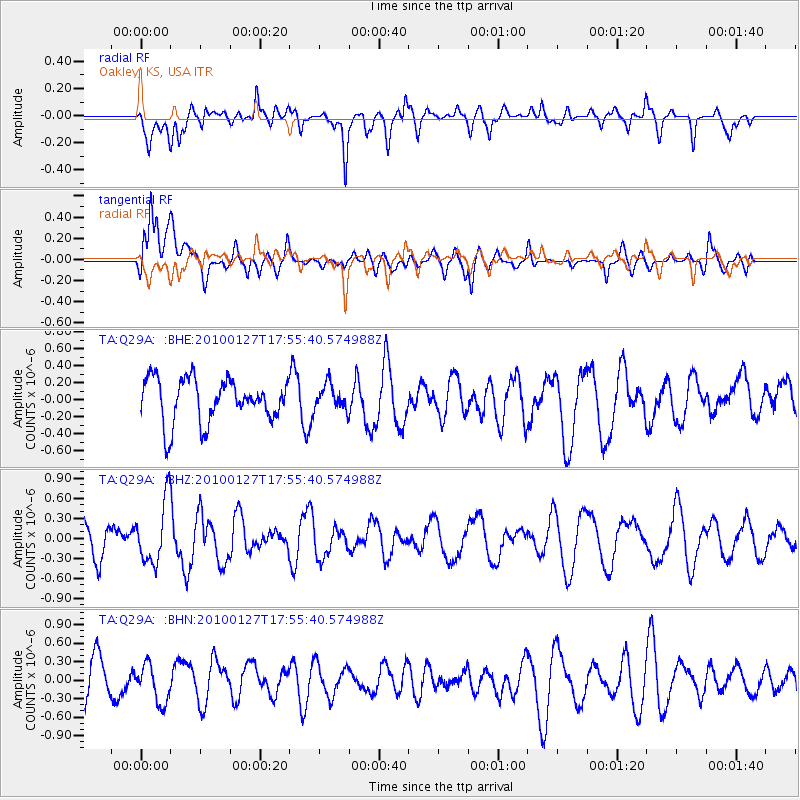
Q29A Oakley, KS, USA - Earthquake Result Viewer
*The percent match for this event was below the threshold and hence no stack was calculated.
| Earthquake location: |
Southern Mid-Atlantic Ridge |
| Earthquake latitude/longitude: |
-14.1/-14.6 |
| Earthquake time(UTC): |
2010/01/27 (027) 17:42:45 GMT |
| Earthquake Depth: |
10 km |
| Earthquake Magnitude: |
6.0 MB, 5.6 MS, 5.8 MW, 5.8 MW |
| Earthquake Catalog/Contributor: |
WHDF/NEIC |
|
| Network: |
TA USArray Transportable Network (new EarthScope stations) |
| Station: |
Q29A Oakley, KS, USA |
| Lat/Lon: |
38.89 N/100.98 W |
| Elevation: |
895 m |
|
| Distance: |
96.0 deg |
| Az: |
308.451 deg |
| Baz: |
103.179 deg |
| Ray Param: |
$rayparam |
*The percent match for this event was below the threshold and hence was not used in the summary stack. |
|
| Radial Match: |
64.59261 % |
| Radial Bump: |
400 |
| Transverse Match: |
54.568855 % |
| Transverse Bump: |
400 |
| SOD ConfigId: |
296938 |
| Insert Time: |
2010-04-07 00:02:45.544 +0000 |
| GWidth: |
2.5 |
| Max Bumps: |
400 |
| Tol: |
0.001 |
|
Signal To Noise
| Channel | StoN | STA | LTA |
| TA:Q29A: :BHZ:20100127T17:55:40.574988Z | 2.26862 | 4.6596386E-7 | 2.0539528E-7 |
| TA:Q29A: :BHN:20100127T17:55:40.574988Z | 0.8677606 | 3.05221E-7 | 3.5173412E-7 |
| TA:Q29A: :BHE:20100127T17:55:40.574988Z | 0.58458966 | 1.472633E-7 | 2.5190883E-7 |
| Arrivals |
| Ps | |
| PpPs | |
| PsPs/PpSs | |


