You are here: Home > Network List > TA - USArray Transportable Network (new EarthScope stations) Stations List
> Station 133A Hamilton Ranch, Breckenridge, TX, USA > Earthquake Result Viewer
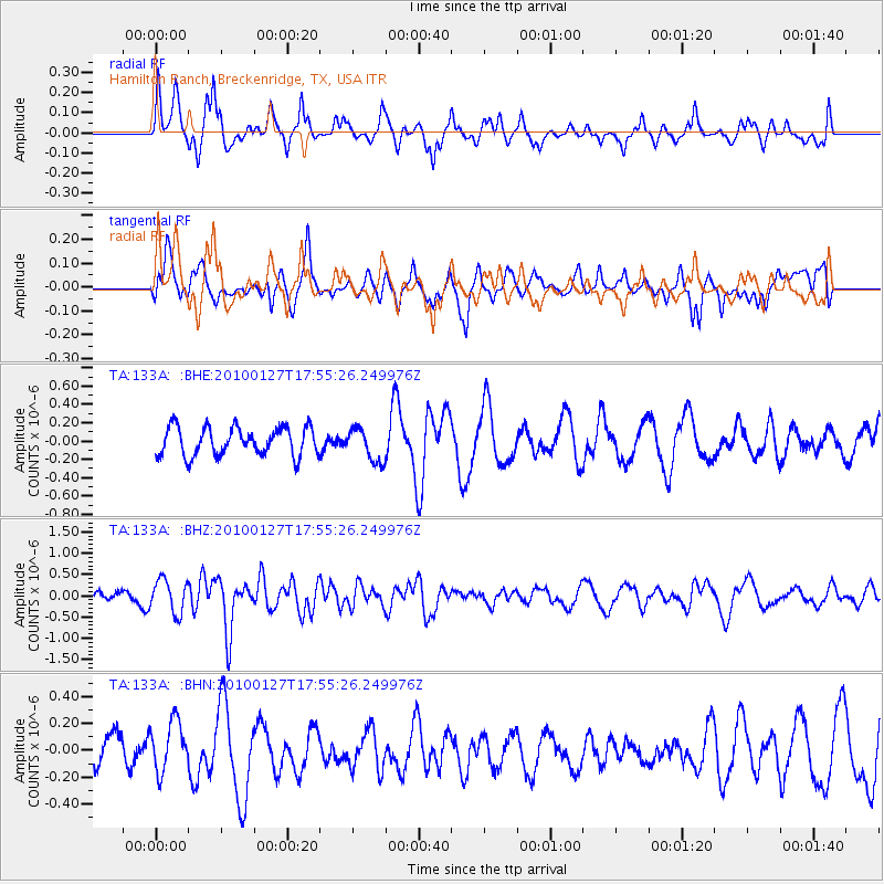
133A Hamilton Ranch, Breckenridge, TX, USA - Earthquake Result Viewer
*The percent match for this event was below the threshold and hence no stack was calculated.
| Earthquake location: |
Southern Mid-Atlantic Ridge |
| Earthquake latitude/longitude: |
-14.1/-14.6 |
| Earthquake time(UTC): |
2010/01/27 (027) 17:42:45 GMT |
| Earthquake Depth: |
10 km |
| Earthquake Magnitude: |
6.0 MB, 5.6 MS, 5.8 MW, 5.8 MW |
| Earthquake Catalog/Contributor: |
WHDF/NEIC |
|
| Network: |
TA USArray Transportable Network (new EarthScope stations) |
| Station: |
133A Hamilton Ranch, Breckenridge, TX, USA |
| Lat/Lon: |
32.61 N/98.92 W |
| Elevation: |
418 m |
|
| Distance: |
92.8 deg |
| Az: |
302.759 deg |
| Baz: |
104.818 deg |
| Ray Param: |
$rayparam |
*The percent match for this event was below the threshold and hence was not used in the summary stack. |
|
| Radial Match: |
65.39684 % |
| Radial Bump: |
348 |
| Transverse Match: |
71.52773 % |
| Transverse Bump: |
400 |
| SOD ConfigId: |
296938 |
| Insert Time: |
2010-04-07 00:03:42.307 +0000 |
| GWidth: |
2.5 |
| Max Bumps: |
400 |
| Tol: |
0.001 |
|
Signal To Noise
| Channel | StoN | STA | LTA |
| TA:133A: :BHZ:20100127T17:55:26.249976Z | 2.5210116 | 3.8883886E-7 | 1.5423922E-7 |
| TA:133A: :BHN:20100127T17:55:26.249976Z | 2.3156753 | 1.9133293E-7 | 8.2625114E-8 |
| TA:133A: :BHE:20100127T17:55:26.249976Z | 1.1509361 | 1.7687121E-7 | 1.5367596E-7 |
| Arrivals |
| Ps | |
| PpPs | |
| PsPs/PpSs | |


