You are here: Home > Network List > TA - USArray Transportable Network (new EarthScope stations) Stations List
> Station 334A Lometa, TX, USA > Earthquake Result Viewer
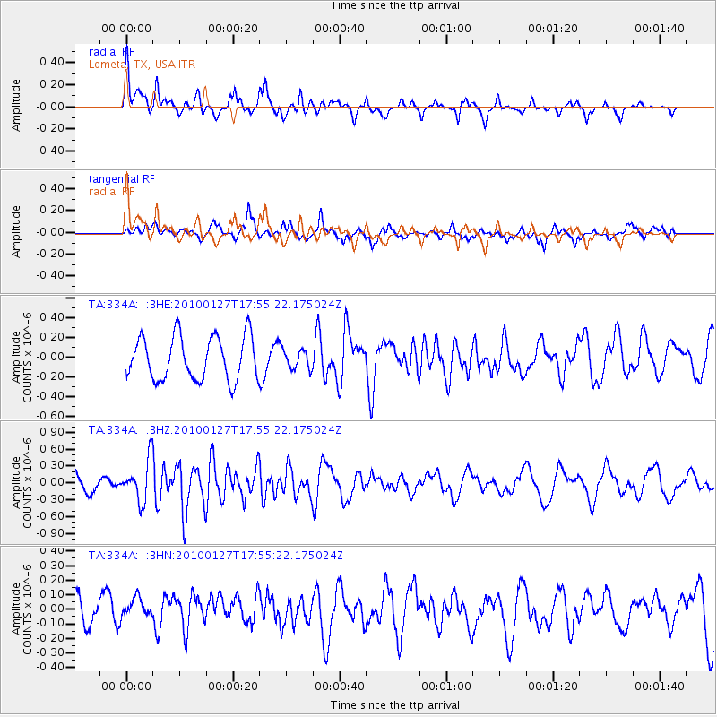
334A Lometa, TX, USA - Earthquake Result Viewer
*The percent match for this event was below the threshold and hence no stack was calculated.
| Earthquake location: |
Southern Mid-Atlantic Ridge |
| Earthquake latitude/longitude: |
-14.1/-14.6 |
| Earthquake time(UTC): |
2010/01/27 (027) 17:42:45 GMT |
| Earthquake Depth: |
10 km |
| Earthquake Magnitude: |
6.0 MB, 5.6 MS, 5.8 MW, 5.8 MW |
| Earthquake Catalog/Contributor: |
WHDF/NEIC |
|
| Network: |
TA USArray Transportable Network (new EarthScope stations) |
| Station: |
334A Lometa, TX, USA |
| Lat/Lon: |
31.33 N/98.24 W |
| Elevation: |
389 m |
|
| Distance: |
91.9 deg |
| Az: |
301.679 deg |
| Baz: |
105.221 deg |
| Ray Param: |
$rayparam |
*The percent match for this event was below the threshold and hence was not used in the summary stack. |
|
| Radial Match: |
61.426792 % |
| Radial Bump: |
400 |
| Transverse Match: |
69.03119 % |
| Transverse Bump: |
399 |
| SOD ConfigId: |
296938 |
| Insert Time: |
2010-04-07 00:03:48.140 +0000 |
| GWidth: |
2.5 |
| Max Bumps: |
400 |
| Tol: |
0.001 |
|
Signal To Noise
| Channel | StoN | STA | LTA |
| TA:334A: :BHZ:20100127T17:55:22.175024Z | 2.297334 | 3.722996E-7 | 1.6205725E-7 |
| TA:334A: :BHN:20100127T17:55:22.175024Z | 0.77170545 | 7.507787E-8 | 9.728825E-8 |
| TA:334A: :BHE:20100127T17:55:22.175024Z | 0.43415007 | 9.5209785E-8 | 2.1930155E-7 |
| Arrivals |
| Ps | |
| PpPs | |
| PsPs/PpSs | |


