You are here: Home > Network List > IU - Global Seismograph Network (GSN - IRIS/USGS) Stations List
> Station CTAO Charters Towers, Australia > Earthquake Result Viewer
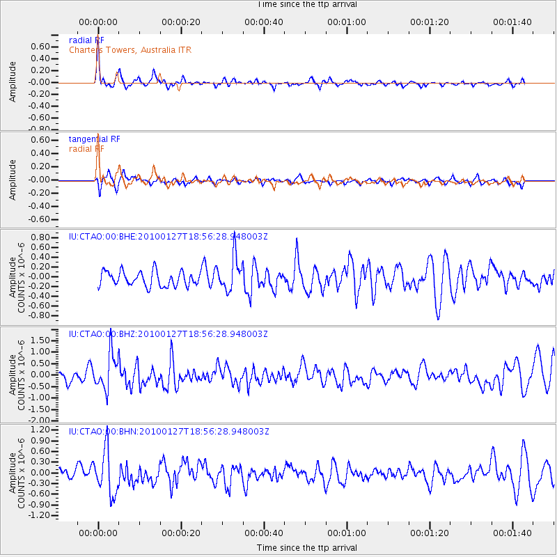
CTAO Charters Towers, Australia - Earthquake Result Viewer
*The percent match for this event was below the threshold and hence no stack was calculated.
| Earthquake location: |
Philippine Islands Region |
| Earthquake latitude/longitude: |
13.6/125.5 |
| Earthquake time(UTC): |
2010/01/27 (027) 18:49:33 GMT |
| Earthquake Depth: |
29 km |
| Earthquake Magnitude: |
5.6 MB, 5.4 MS, 5.9 MW, 5.9 MW |
| Earthquake Catalog/Contributor: |
WHDF/NEIC |
|
| Network: |
IU Global Seismograph Network (GSN - IRIS/USGS) |
| Station: |
CTAO Charters Towers, Australia |
| Lat/Lon: |
20.09 S/146.25 E |
| Elevation: |
357 m |
|
| Distance: |
39.3 deg |
| Az: |
148.215 deg |
| Baz: |
326.989 deg |
| Ray Param: |
$rayparam |
*The percent match for this event was below the threshold and hence was not used in the summary stack. |
|
| Radial Match: |
72.30913 % |
| Radial Bump: |
400 |
| Transverse Match: |
67.05014 % |
| Transverse Bump: |
400 |
| SOD ConfigId: |
296938 |
| Insert Time: |
2010-04-07 00:07:10.592 +0000 |
| GWidth: |
2.5 |
| Max Bumps: |
400 |
| Tol: |
0.001 |
|
Signal To Noise
| Channel | StoN | STA | LTA |
| IU:CTAO:00:BHZ:20100127T18:56:28.948003Z | 2.5852594 | 8.049625E-7 | 3.1136625E-7 |
| IU:CTAO:00:BHN:20100127T18:56:28.948003Z | 5.5499954 | 6.299801E-7 | 1.13510026E-7 |
| IU:CTAO:00:BHE:20100127T18:56:28.948003Z | 2.3911495 | 3.5606837E-7 | 1.4891096E-7 |
| Arrivals |
| Ps | |
| PpPs | |
| PsPs/PpSs | |


