You are here: Home > Network List > KN - Kyrgyz Seismic Telemetry Network Stations List
> Station CHM KN.CHM > Earthquake Result Viewer
CHM KN.CHM - Earthquake Result Viewer
*The percent match for this event was below the threshold and hence no stack was calculated.
| Earthquake location: |
Philippine Islands Region |
| Earthquake latitude/longitude: |
13.6/125.5 |
| Earthquake time(UTC): |
2010/01/27 (027) 18:49:33 GMT |
| Earthquake Depth: |
29 km |
| Earthquake Magnitude: |
5.6 MB, 5.4 MS, 5.9 MW, 5.9 MW |
| Earthquake Catalog/Contributor: |
WHDF/NEIC |
|
| Network: |
KN Kyrgyz Seismic Telemetry Network |
| Station: |
CHM KN.CHM |
| Lat/Lon: |
43.00 N/74.75 E |
| Elevation: |
655 m |
|
| Distance: |
52.4 deg |
| Az: |
314.171 deg |
| Baz: |
108.113 deg |
| Ray Param: |
$rayparam |
*The percent match for this event was below the threshold and hence was not used in the summary stack. |
|
| Radial Match: |
57.604225 % |
| Radial Bump: |
400 |
| Transverse Match: |
78.009285 % |
| Transverse Bump: |
400 |
| SOD ConfigId: |
296938 |
| Insert Time: |
2010-04-07 00:07:32.304 +0000 |
| GWidth: |
2.5 |
| Max Bumps: |
400 |
| Tol: |
0.001 |
|
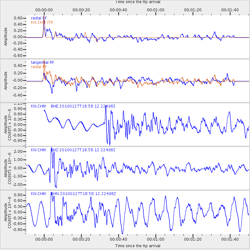
Signal To Noise
| Channel | StoN | STA | LTA |
| KN:CHM: :BHZ:20100127T18:58:12.22498Z | 4.6478286 | 9.942074E-7 | 2.1390795E-7 |
| KN:CHM: :BHN:20100127T18:58:12.22498Z | 1.932857 | 5.840422E-7 | 3.0216523E-7 |
| KN:CHM: :BHE:20100127T18:58:12.22498Z | 1.7279335 | 4.6503797E-7 | 2.6912954E-7 |
| Arrivals |
| Ps | |
| PpPs | |
| PsPs/PpSs | |


