You are here: Home > Network List > KN - Kyrgyz Seismic Telemetry Network Stations List
> Station TKM2 KN.TKM2 > Earthquake Result Viewer
TKM2 KN.TKM2 - Earthquake Result Viewer
*The percent match for this event was below the threshold and hence no stack was calculated.
| Earthquake location: |
Philippine Islands Region |
| Earthquake latitude/longitude: |
13.6/125.5 |
| Earthquake time(UTC): |
2010/01/27 (027) 18:49:33 GMT |
| Earthquake Depth: |
29 km |
| Earthquake Magnitude: |
5.6 MB, 5.4 MS, 5.9 MW, 5.9 MW |
| Earthquake Catalog/Contributor: |
WHDF/NEIC |
|
| Network: |
KN Kyrgyz Seismic Telemetry Network |
| Station: |
TKM2 KN.TKM2 |
| Lat/Lon: |
42.92 N/75.60 E |
| Elevation: |
2020 m |
|
| Distance: |
51.8 deg |
| Az: |
314.327 deg |
| Baz: |
108.783 deg |
| Ray Param: |
$rayparam |
*The percent match for this event was below the threshold and hence was not used in the summary stack. |
|
| Radial Match: |
60.095947 % |
| Radial Bump: |
400 |
| Transverse Match: |
59.42473 % |
| Transverse Bump: |
379 |
| SOD ConfigId: |
296938 |
| Insert Time: |
2010-04-07 00:08:17.037 +0000 |
| GWidth: |
2.5 |
| Max Bumps: |
400 |
| Tol: |
0.001 |
|
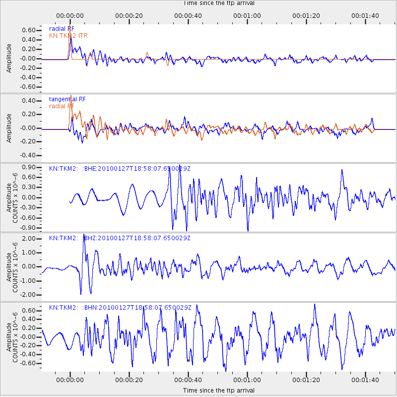
Signal To Noise
| Channel | StoN | STA | LTA |
| KN:TKM2: :BHZ:20100127T18:58:07.650029Z | 5.033206 | 8.358864E-7 | 1.6607434E-7 |
| KN:TKM2: :BHN:20100127T18:58:07.650029Z | 1.095407 | 2.0148866E-7 | 1.8393953E-7 |
| KN:TKM2: :BHE:20100127T18:58:07.650029Z | 1.9101695 | 3.7621678E-7 | 1.9695464E-7 |
| Arrivals |
| Ps | |
| PpPs | |
| PsPs/PpSs | |


