You are here: Home > Network List > CI - Caltech Regional Seismic Network Stations List
> Station FUR Furnace Creek, CA, USA > Earthquake Result Viewer
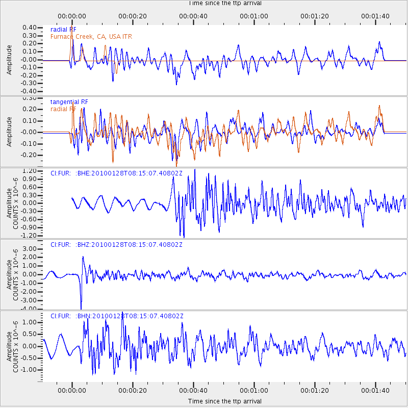
FUR Furnace Creek, CA, USA - Earthquake Result Viewer
*The percent match for this event was below the threshold and hence no stack was calculated.
| Earthquake location: |
Jujuy Province, Argentina |
| Earthquake latitude/longitude: |
-23.4/-66.7 |
| Earthquake time(UTC): |
2010/01/28 (028) 08:04:14 GMT |
| Earthquake Depth: |
208 km |
| Earthquake Magnitude: |
5.8 MB, 5.9 MW, 5.9 MW |
| Earthquake Catalog/Contributor: |
WHDF/NEIC |
|
| Network: |
CI Caltech Regional Seismic Network |
| Station: |
FUR Furnace Creek, CA, USA |
| Lat/Lon: |
36.47 N/116.86 W |
| Elevation: |
-37.0 m |
|
| Distance: |
76.0 deg |
| Az: |
320.377 deg |
| Baz: |
133.359 deg |
| Ray Param: |
$rayparam |
*The percent match for this event was below the threshold and hence was not used in the summary stack. |
|
| Radial Match: |
59.388184 % |
| Radial Bump: |
400 |
| Transverse Match: |
66.99428 % |
| Transverse Bump: |
400 |
| SOD ConfigId: |
296938 |
| Insert Time: |
2010-04-07 00:13:18.480 +0000 |
| GWidth: |
2.5 |
| Max Bumps: |
400 |
| Tol: |
0.001 |
|
Signal To Noise
| Channel | StoN | STA | LTA |
| CI:FUR: :BHZ:20100128T08:15:07.40802Z | 3.327465 | 1.1409265E-6 | 3.428816E-7 |
| CI:FUR: :BHN:20100128T08:15:07.40802Z | 1.2724476 | 3.9465093E-7 | 3.1015102E-7 |
| CI:FUR: :BHE:20100128T08:15:07.40802Z | 2.4974663 | 3.902503E-7 | 1.5625848E-7 |
| Arrivals |
| Ps | |
| PpPs | |
| PsPs/PpSs | |


