You are here: Home > Network List > CI - Caltech Regional Seismic Network Stations List
> Station MPM Manuel Prospect Mine, California, USA > Earthquake Result Viewer
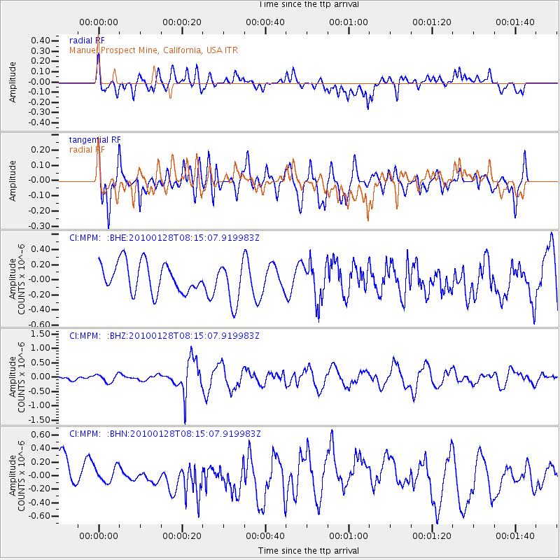
MPM Manuel Prospect Mine, California, USA - Earthquake Result Viewer
*The percent match for this event was below the threshold and hence no stack was calculated.
| Earthquake location: |
Jujuy Province, Argentina |
| Earthquake latitude/longitude: |
-23.4/-66.7 |
| Earthquake time(UTC): |
2010/01/28 (028) 08:04:14 GMT |
| Earthquake Depth: |
208 km |
| Earthquake Magnitude: |
5.8 MB, 5.9 MW, 5.9 MW |
| Earthquake Catalog/Contributor: |
WHDF/NEIC |
|
| Network: |
CI Caltech Regional Seismic Network |
| Station: |
MPM Manuel Prospect Mine, California, USA |
| Lat/Lon: |
36.06 N/117.49 W |
| Elevation: |
185 m |
|
| Distance: |
76.1 deg |
| Az: |
319.714 deg |
| Baz: |
132.831 deg |
| Ray Param: |
$rayparam |
*The percent match for this event was below the threshold and hence was not used in the summary stack. |
|
| Radial Match: |
38.660324 % |
| Radial Bump: |
400 |
| Transverse Match: |
68.789375 % |
| Transverse Bump: |
400 |
| SOD ConfigId: |
296938 |
| Insert Time: |
2010-04-07 00:13:49.950 +0000 |
| GWidth: |
2.5 |
| Max Bumps: |
400 |
| Tol: |
0.001 |
|
Signal To Noise
| Channel | StoN | STA | LTA |
| CI:MPM: :BHZ:20100128T08:15:07.919983Z | 0.46359417 | 1.4124821E-7 | 3.0468073E-7 |
| CI:MPM: :BHN:20100128T08:15:07.919983Z | 0.55124533 | 1.2027165E-7 | 2.1818171E-7 |
| CI:MPM: :BHE:20100128T08:15:07.919983Z | 1.5002116 | 2.8754306E-7 | 1.9166833E-7 |
| Arrivals |
| Ps | |
| PpPs | |
| PsPs/PpSs | |


