You are here: Home > Network List > UM - University of Montana - Missoula Stations List
> Station GBMT Granite Butte > Earthquake Result Viewer
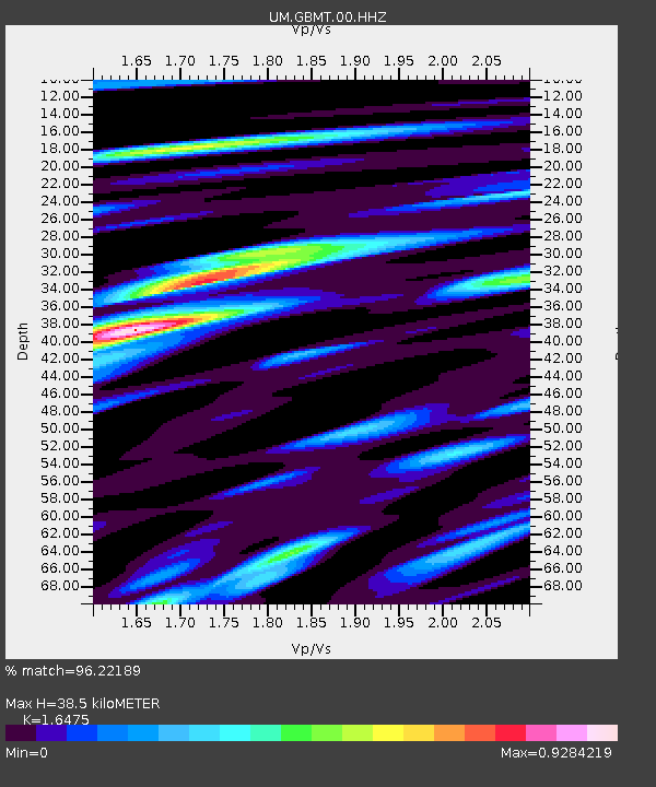
GBMT Granite Butte - Earthquake Result Viewer
| Earthquake location: |
Tonga Islands |
| Earthquake latitude/longitude: |
-15.4/-173.2 |
| Earthquake time(UTC): |
2017/11/04 (308) 09:00:19 GMT |
| Earthquake Depth: |
10 km |
| Earthquake Magnitude: |
6.8 Mww |
| Earthquake Catalog/Contributor: |
NEIC PDE/us |
|
| Network: |
UM University of Montana - Missoula |
| Station: |
GBMT Granite Butte |
| Lat/Lon: |
46.86 N/112.46 W |
| Elevation: |
2235 m |
|
| Distance: |
82.4 deg |
| Az: |
37.163 deg |
| Baz: |
238.132 deg |
| Ray Param: |
0.04690052 |
| Estimated Moho Depth: |
38.5 km |
| Estimated Crust Vp/Vs: |
1.65 |
| Assumed Crust Vp: |
6.353 km/s |
| Estimated Crust Vs: |
3.856 km/s |
| Estimated Crust Poisson's Ratio: |
0.21 |
|
| Radial Match: |
96.22189 % |
| Radial Bump: |
361 |
| Transverse Match: |
87.33881 % |
| Transverse Bump: |
400 |
| SOD ConfigId: |
2973751 |
| Insert Time: |
2018-10-09 01:13:20.106 +0000 |
| GWidth: |
2.5 |
| Max Bumps: |
400 |
| Tol: |
0.001 |
|

Signal To Noise
| Channel | StoN | STA | LTA |
| UM:GBMT:00:HHZ:20171104T09:12:09.930012Z | 63.85783 | 5.065382E-6 | 7.932281E-8 |
| UM:GBMT:00:HHN:20171104T09:12:09.930012Z | 7.5116386 | 1.2175082E-6 | 1.620829E-7 |
| UM:GBMT:00:HHE:20171104T09:12:09.930012Z | 16.801357 | 1.8275961E-6 | 1.0877669E-7 |
| Arrivals |
| Ps | 4.0 SECOND |
| PpPs | 16 SECOND |
| PsPs/PpSs | 20 SECOND |


