You are here: Home > Network List > GM - US Geological Survey Networks Stations List
> Station NMP23 New Mexico Permian - Site# W2S3 > Earthquake Result Viewer
NMP23 New Mexico Permian - Site# W2S3 - Earthquake Result Viewer
| Earthquake location: |
Pacific-Antarctic Ridge |
| Earthquake latitude/longitude: |
-55.1/-128.5 |
| Earthquake time(UTC): |
2022/11/27 (331) 14:04:10 GMT |
| Earthquake Depth: |
10 km |
| Earthquake Magnitude: |
5.5 Mww |
| Earthquake Catalog/Contributor: |
NEIC PDE/us |
|
| Network: |
GM US Geological Survey Networks |
| Station: |
NMP23 New Mexico Permian - Site# W2S3 |
| Lat/Lon: |
32.17 N/103.80 W |
| Elevation: |
1050 m |
|
| Distance: |
89.5 deg |
| Az: |
20.773 deg |
| Baz: |
193.905 deg |
| Ray Param: |
0.04182237 |
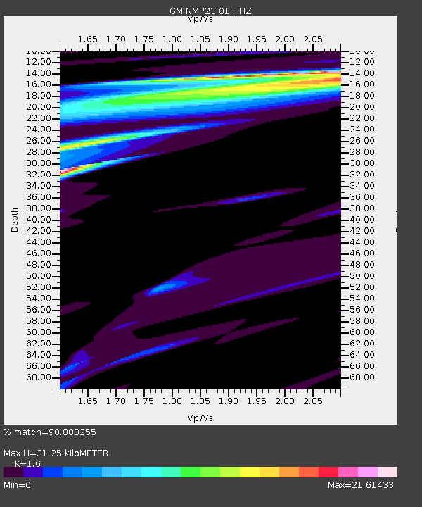
| Estimated Moho Depth: |
31.25 km |
| Estimated Crust Vp/Vs: |
1.60 |
| Assumed Crust Vp: |
6.129 km/s |
| Estimated Crust Vs: |
3.831 km/s |
| Estimated Crust Poisson's Ratio: |
0.18 |
|
| Radial Match: |
98.008255 % |
| Radial Bump: |
146 |
| Transverse Match: |
98.023544 % |
| Transverse Bump: |
145 |
| SOD ConfigId: |
29823551 |
| Insert Time: |
2022-12-11 14:10:28.130 +0000 |
| GWidth: |
2.5 |
| Max Bumps: |
400 |
| Tol: |
0.001 |
|

Signal To Noise
| Channel | StoN | STA | LTA |
| GM:NMP23:01:HHZ:20221127T14:16:36.030004Z | 1.8776779 | 4.8648963E-6 | 2.5909108E-6 |
| GM:NMP23:01:HHN:20221127T14:16:36.030004Z | 1.7781353 | 2.4660115E-4 | 1.3868527E-4 |
| GM:NMP23:01:HHE:20221127T14:16:36.030004Z | 1.6927826 | 2.9049843E-5 | 1.7161E-5 |
| Arrivals |
| Ps | 3.1 SECOND |
| PpPs | 13 SECOND |
| PsPs/PpSs | 16 SECOND |


