You are here: Home > Network List > XA95 - Missouri to Massachusetts Transect Stations List
> Station MM12 Laura, Ohio > Earthquake Result Viewer
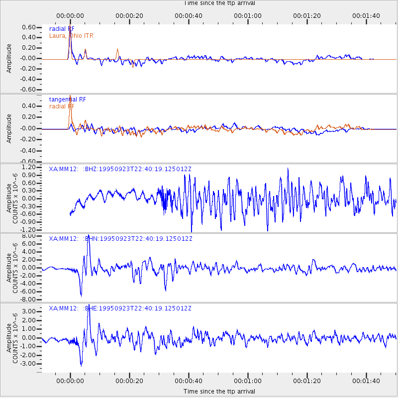
MM12 Laura, Ohio - Earthquake Result Viewer
*The percent match for this event was below the threshold and hence no stack was calculated.
| Earthquake location: |
Near Coast Of Peru |
| Earthquake latitude/longitude: |
-10.5/-78.7 |
| Earthquake time(UTC): |
1995/09/23 (266) 22:31:58 GMT |
| Earthquake Depth: |
73 km |
| Earthquake Magnitude: |
5.9 MB, 6.5 UNKNOWN, 6.4 MW |
| Earthquake Catalog/Contributor: |
WHDF/NEIC |
|
| Network: |
XA Missouri to Massachusetts Transect |
| Station: |
MM12 Laura, Ohio |
| Lat/Lon: |
40.04 N/84.37 W |
| Elevation: |
305 m |
|
| Distance: |
50.6 deg |
| Az: |
354.361 deg |
| Baz: |
172.769 deg |
| Ray Param: |
$rayparam |
*The percent match for this event was below the threshold and hence was not used in the summary stack. |
|
| Radial Match: |
77.90461 % |
| Radial Bump: |
400 |
| Transverse Match: |
69.13939 % |
| Transverse Bump: |
400 |
| SOD ConfigId: |
4480 |
| Insert Time: |
2010-02-26 17:52:57.201 +0000 |
| GWidth: |
2.5 |
| Max Bumps: |
400 |
| Tol: |
0.001 |
|
Signal To Noise
| Channel | StoN | STA | LTA |
| XA:MM12: :BHN:19950923T22:40:19.125012Z | 13.538637 | 2.3883574E-6 | 1.7641048E-7 |
| XA:MM12: :BHE:19950923T22:40:19.125012Z | 3.017695 | 1.4050055E-6 | 4.6558895E-7 |
| XA:MM12: :BHZ:19950923T22:40:19.125012Z | 1.1401805 | 2.5655712E-7 | 2.2501449E-7 |
| Arrivals |
| Ps | |
| PpPs | |
| PsPs/PpSs | |


