You are here: Home > Network List > CM - Red Sismologica Nacional de Columbia Stations List
> Station SMAR Santa Marta, Magdalena, Colombia > Earthquake Result Viewer
SMAR Santa Marta, Magdalena, Colombia - Earthquake Result Viewer
| Earthquake location: |
Azores Islands Region |
| Earthquake latitude/longitude: |
37.1/-32.4 |
| Earthquake time(UTC): |
2022/11/28 (332) 02:51:23 GMT |
| Earthquake Depth: |
10 km |
| Earthquake Magnitude: |
5.9 mww |
| Earthquake Catalog/Contributor: |
NEIC PDE/us |
|
| Network: |
CM Red Sismologica Nacional de Columbia |
| Station: |
SMAR Santa Marta, Magdalena, Colombia |
| Lat/Lon: |
11.16 N/74.22 W |
| Elevation: |
122 m |
|
| Distance: |
45.5 deg |
| Az: |
246.441 deg |
| Baz: |
48.326 deg |
| Ray Param: |
0.0712105 |
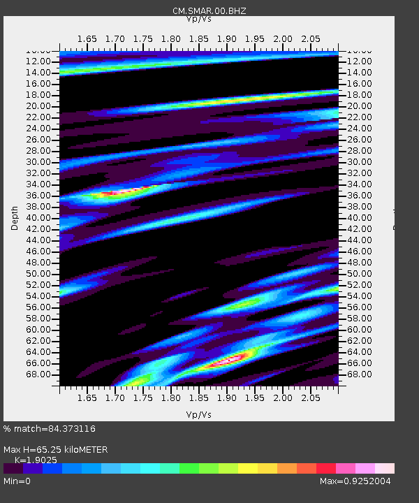
| Estimated Moho Depth: |
65.25 km |
| Estimated Crust Vp/Vs: |
1.90 |
| Assumed Crust Vp: |
5.129 km/s |
| Estimated Crust Vs: |
2.696 km/s |
| Estimated Crust Poisson's Ratio: |
0.31 |
|
| Radial Match: |
84.373116 % |
| Radial Bump: |
375 |
| Transverse Match: |
56.104576 % |
| Transverse Bump: |
400 |
| SOD ConfigId: |
29823551 |
| Insert Time: |
2022-12-12 03:02:08.479 +0000 |
| GWidth: |
2.5 |
| Max Bumps: |
400 |
| Tol: |
0.001 |
|

Signal To Noise
| Channel | StoN | STA | LTA |
| CM:SMAR:00:BHZ:20221128T02:59:12.569001Z | 3.4552224 | 5.6534265E-7 | 1.6361976E-7 |
| CM:SMAR:00:BHN:20221128T02:59:12.569001Z | 1.4504095 | 1.9357604E-7 | 1.3346302E-7 |
| CM:SMAR:00:BHE:20221128T02:59:12.569001Z | 2.05757 | 2.6049764E-7 | 1.266045E-7 |
| Arrivals |
| Ps | 12 SECOND |
| PpPs | 36 SECOND |
| PsPs/PpSs | 48 SECOND |


