You are here: Home > Network List > G - GEOSCOPE Stations List
> Station MPG Montagne des Peres, French Guyana > Earthquake Result Viewer
MPG Montagne des Peres, French Guyana - Earthquake Result Viewer
| Earthquake location: |
Azores Islands Region |
| Earthquake latitude/longitude: |
37.1/-32.4 |
| Earthquake time(UTC): |
2022/11/28 (332) 02:51:23 GMT |
| Earthquake Depth: |
10 km |
| Earthquake Magnitude: |
5.9 mww |
| Earthquake Catalog/Contributor: |
NEIC PDE/us |
|
| Network: |
G GEOSCOPE |
| Station: |
MPG Montagne des Peres, French Guyana |
| Lat/Lon: |
5.11 N/52.64 W |
| Elevation: |
147 m |
|
| Distance: |
36.8 deg |
| Az: |
215.092 deg |
| Baz: |
27.485 deg |
| Ray Param: |
0.076496795 |
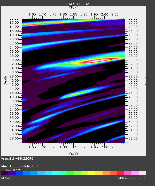
| Estimated Moho Depth: |
30.0 km |
| Estimated Crust Vp/Vs: |
1.98 |
| Assumed Crust Vp: |
6.472 km/s |
| Estimated Crust Vs: |
3.273 km/s |
| Estimated Crust Poisson's Ratio: |
0.33 |
|
| Radial Match: |
89.22096 % |
| Radial Bump: |
323 |
| Transverse Match: |
62.03365 % |
| Transverse Bump: |
400 |
| SOD ConfigId: |
29823551 |
| Insert Time: |
2022-12-12 03:04:37.686 +0000 |
| GWidth: |
2.5 |
| Max Bumps: |
400 |
| Tol: |
0.001 |
|

Signal To Noise
| Channel | StoN | STA | LTA |
| G:MPG:00:BHZ:20221128T02:58:00.998994Z | 2.9118466 | 4.889811E-7 | 1.6792818E-7 |
| G:MPG:00:BHN:20221128T02:58:00.998994Z | 3.2417665 | 3.2190775E-7 | 9.93001E-8 |
| G:MPG:00:BHE:20221128T02:58:00.998994Z | 1.645746 | 1.7313248E-7 | 1.052E-7 |
| Arrivals |
| Ps | 4.8 SECOND |
| PpPs | 13 SECOND |
| PsPs/PpSs | 18 SECOND |


