You are here: Home > Network List > GO - National Seismic Network of Georgia Stations List
> Station EMLK Emlikli, Georgia > Earthquake Result Viewer
EMLK Emlikli, Georgia - Earthquake Result Viewer
| Earthquake location: |
Azores Islands Region |
| Earthquake latitude/longitude: |
37.1/-32.4 |
| Earthquake time(UTC): |
2022/11/28 (332) 02:51:23 GMT |
| Earthquake Depth: |
10 km |
| Earthquake Magnitude: |
5.9 mww |
| Earthquake Catalog/Contributor: |
NEIC PDE/us |
|
| Network: |
GO National Seismic Network of Georgia |
| Station: |
EMLK Emlikli, Georgia |
| Lat/Lon: |
41.21 N/43.95 E |
| Elevation: |
2939 m |
|
| Distance: |
57.6 deg |
| Az: |
60.313 deg |
| Baz: |
292.962 deg |
| Ray Param: |
0.06342084 |
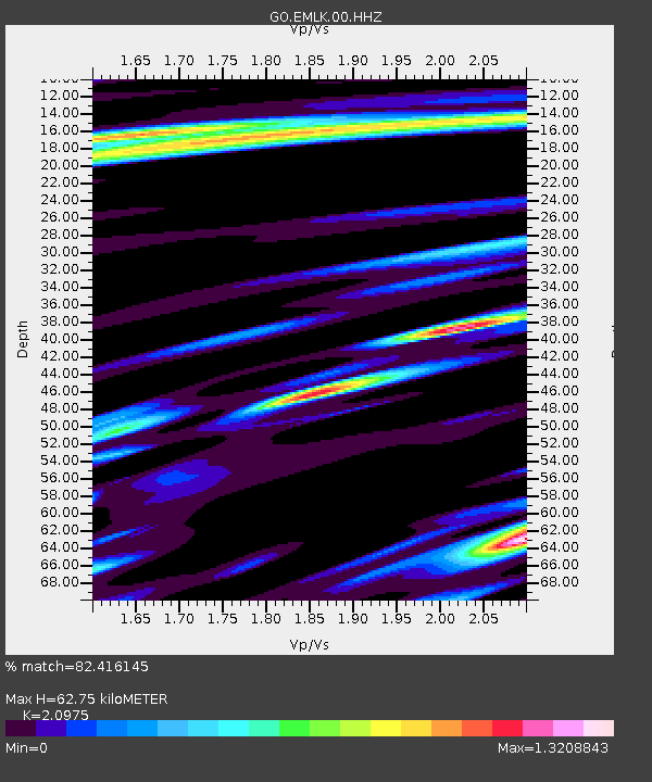
| Estimated Moho Depth: |
62.75 km |
| Estimated Crust Vp/Vs: |
2.10 |
| Assumed Crust Vp: |
6.419 km/s |
| Estimated Crust Vs: |
3.06 km/s |
| Estimated Crust Poisson's Ratio: |
0.35 |
|
| Radial Match: |
82.416145 % |
| Radial Bump: |
400 |
| Transverse Match: |
77.60188 % |
| Transverse Bump: |
400 |
| SOD ConfigId: |
29823551 |
| Insert Time: |
2022-12-12 03:05:29.182 +0000 |
| GWidth: |
2.5 |
| Max Bumps: |
400 |
| Tol: |
0.001 |
|

Signal To Noise
| Channel | StoN | STA | LTA |
| GO:EMLK:00:HHZ:20221128T03:00:42.249971Z | 12.08027 | 1.4128688E-6 | 1.1695673E-7 |
| GO:EMLK:00:HHN:20221128T03:00:42.249971Z | 0.82583857 | 1.1950364E-7 | 1.4470581E-7 |
| GO:EMLK:00:HHE:20221128T03:00:42.249971Z | 2.8492892 | 4.4995986E-7 | 1.5792004E-7 |
| Arrivals |
| Ps | 11 SECOND |
| PpPs | 29 SECOND |
| PsPs/PpSs | 40 SECOND |


