You are here: Home > Network List > GT - Global Telemetered Seismograph Network (USAF/USGS) Stations List
> Station LPAZ La Paz , Bolivia > Earthquake Result Viewer
LPAZ La Paz , Bolivia - Earthquake Result Viewer
| Earthquake location: |
Azores Islands Region |
| Earthquake latitude/longitude: |
37.1/-32.4 |
| Earthquake time(UTC): |
2022/11/28 (332) 02:51:23 GMT |
| Earthquake Depth: |
10 km |
| Earthquake Magnitude: |
5.9 mww |
| Earthquake Catalog/Contributor: |
NEIC PDE/us |
|
| Network: |
GT Global Telemetered Seismograph Network (USAF/USGS) |
| Station: |
LPAZ La Paz , Bolivia |
| Lat/Lon: |
16.17 S/68.08 W |
| Elevation: |
4817 m |
|
| Distance: |
62.7 deg |
| Az: |
219.078 deg |
| Baz: |
31.64 deg |
| Ray Param: |
0.060025528 |
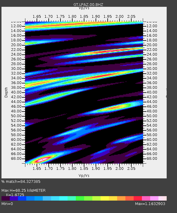
| Estimated Moho Depth: |
68.25 km |
| Estimated Crust Vp/Vs: |
1.67 |
| Assumed Crust Vp: |
6.454 km/s |
| Estimated Crust Vs: |
3.859 km/s |
| Estimated Crust Poisson's Ratio: |
0.22 |
|
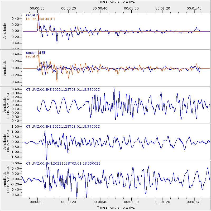
| Radial Match: |
84.327385 % |
| Radial Bump: |
400 |
| Transverse Match: |
65.85358 % |
| Transverse Bump: |
400 |
| SOD ConfigId: |
29823551 |
| Insert Time: |
2022-12-12 03:06:14.513 +0000 |
| GWidth: |
2.5 |
| Max Bumps: |
400 |
| Tol: |
0.001 |
|
Signal To Noise
| Channel | StoN | STA | LTA |
| GT:LPAZ:00:BHZ:20221128T03:01:18.55002Z | 5.788941 | 3.2172963E-7 | 5.5576596E-8 |
| GT:LPAZ:00:BHN:20221128T03:01:18.55002Z | 0.87265474 | 1.0601282E-7 | 1.2148311E-7 |
| GT:LPAZ:00:BHE:20221128T03:01:18.55002Z | 0.9612484 | 1.0978651E-7 | 1.1421243E-7 |
| Arrivals |
| Ps | 7.5 SECOND |
| PpPs | 27 SECOND |
| PsPs/PpSs | 34 SECOND |


