You are here: Home > Network List > XA95 - Missouri to Massachusetts Transect Stations List
> Station MM12 Laura, Ohio > Earthquake Result Viewer
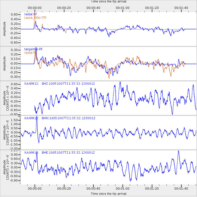
MM12 Laura, Ohio - Earthquake Result Viewer
*The percent match for this event was below the threshold and hence no stack was calculated.
| Earthquake location: |
Peru-Ecuador Border Region |
| Earthquake latitude/longitude: |
-2.8/-77.8 |
| Earthquake time(UTC): |
1995/10/07 (280) 21:28:06 GMT |
| Earthquake Depth: |
33 km |
| Earthquake Magnitude: |
5.8 MB, 5.2 MS, 5.8 UNKNOWN |
| Earthquake Catalog/Contributor: |
WHDF/NEIC |
|
| Network: |
XA Missouri to Massachusetts Transect |
| Station: |
MM12 Laura, Ohio |
| Lat/Lon: |
40.04 N/84.37 W |
| Elevation: |
305 m |
|
| Distance: |
43.0 deg |
| Az: |
352.648 deg |
| Baz: |
170.416 deg |
| Ray Param: |
$rayparam |
*The percent match for this event was below the threshold and hence was not used in the summary stack. |
|
| Radial Match: |
42.796864 % |
| Radial Bump: |
400 |
| Transverse Match: |
38.551502 % |
| Transverse Bump: |
400 |
| SOD ConfigId: |
4480 |
| Insert Time: |
2010-02-26 17:53:00.331 +0000 |
| GWidth: |
2.5 |
| Max Bumps: |
400 |
| Tol: |
0.001 |
|
Signal To Noise
| Channel | StoN | STA | LTA |
| XA:MM12: :BHN:19951007T21:35:32.126001Z | 3.0941615 | 7.5504096E-7 | 2.4402118E-7 |
| XA:MM12: :BHE:19951007T21:35:32.126001Z | 1.8341361 | 4.9440484E-7 | 2.6955732E-7 |
| XA:MM12: :BHZ:19951007T21:35:32.126001Z | 0.9966924 | 2.596587E-7 | 2.605204E-7 |
| Arrivals |
| Ps | |
| PpPs | |
| PsPs/PpSs | |


