You are here: Home > Network List > TA - USArray Transportable Network (new EarthScope stations) Stations List
> Station F19A Roth Fram, Molt, MT, USA > Earthquake Result Viewer
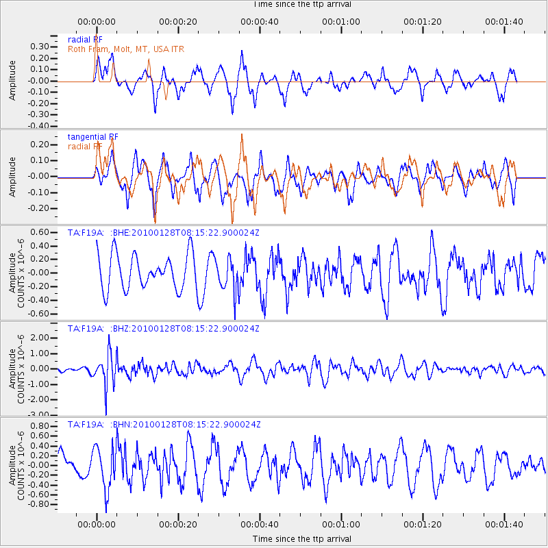
F19A Roth Fram, Molt, MT, USA - Earthquake Result Viewer
*The percent match for this event was below the threshold and hence no stack was calculated.
| Earthquake location: |
Jujuy Province, Argentina |
| Earthquake latitude/longitude: |
-23.4/-66.7 |
| Earthquake time(UTC): |
2010/01/28 (028) 08:04:14 GMT |
| Earthquake Depth: |
208 km |
| Earthquake Magnitude: |
5.8 MB, 5.9 MW, 5.9 MW |
| Earthquake Catalog/Contributor: |
WHDF/NEIC |
|
| Network: |
TA USArray Transportable Network (new EarthScope stations) |
| Station: |
F19A Roth Fram, Molt, MT, USA |
| Lat/Lon: |
45.85 N/108.94 W |
| Elevation: |
1243 m |
|
| Distance: |
78.8 deg |
| Az: |
331.392 deg |
| Baz: |
140.978 deg |
| Ray Param: |
$rayparam |
*The percent match for this event was below the threshold and hence was not used in the summary stack. |
|
| Radial Match: |
63.778107 % |
| Radial Bump: |
394 |
| Transverse Match: |
51.59546 % |
| Transverse Bump: |
330 |
| SOD ConfigId: |
296938 |
| Insert Time: |
2010-04-07 00:34:23.513 +0000 |
| GWidth: |
2.5 |
| Max Bumps: |
400 |
| Tol: |
0.001 |
|
Signal To Noise
| Channel | StoN | STA | LTA |
| TA:F19A: :BHZ:20100128T08:15:22.900024Z | 5.8044963 | 1.0257571E-6 | 1.7671768E-7 |
| TA:F19A: :BHN:20100128T08:15:22.900024Z | 1.0828996 | 4.3718813E-7 | 4.0371992E-7 |
| TA:F19A: :BHE:20100128T08:15:22.900024Z | 0.94769794 | 2.3925531E-7 | 2.5245947E-7 |
| Arrivals |
| Ps | |
| PpPs | |
| PsPs/PpSs | |


