You are here: Home > Network List > TA - USArray Transportable Network (new EarthScope stations) Stations List
> Station C23A Lambert, MT, USA > Earthquake Result Viewer
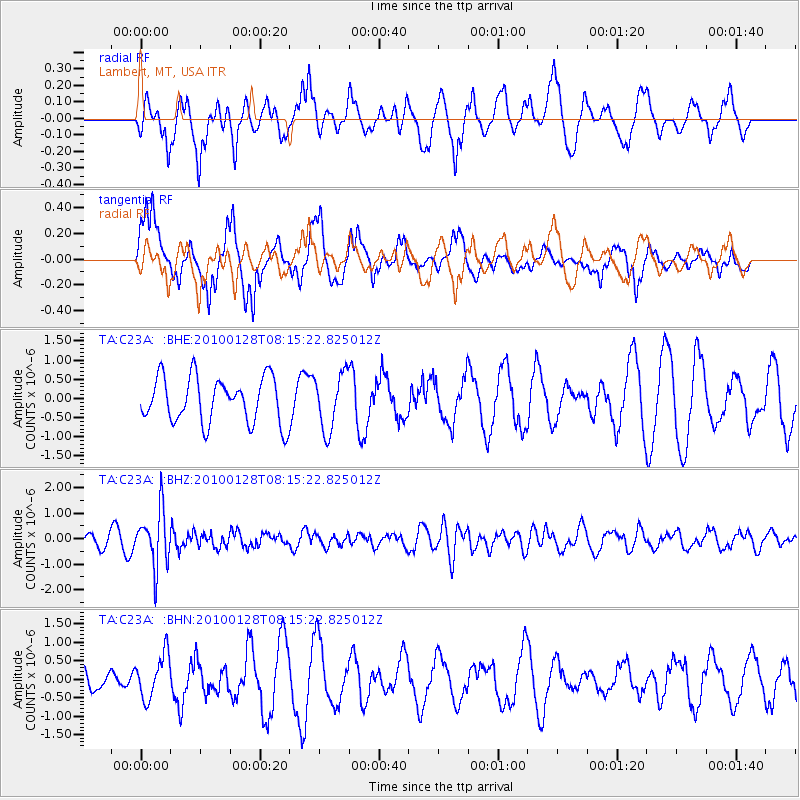
C23A Lambert, MT, USA - Earthquake Result Viewer
*The percent match for this event was below the threshold and hence no stack was calculated.
| Earthquake location: |
Jujuy Province, Argentina |
| Earthquake latitude/longitude: |
-23.4/-66.7 |
| Earthquake time(UTC): |
2010/01/28 (028) 08:04:14 GMT |
| Earthquake Depth: |
208 km |
| Earthquake Magnitude: |
5.8 MB, 5.9 MW, 5.9 MW |
| Earthquake Catalog/Contributor: |
WHDF/NEIC |
|
| Network: |
TA USArray Transportable Network (new EarthScope stations) |
| Station: |
C23A Lambert, MT, USA |
| Lat/Lon: |
47.80 N/105.18 W |
| Elevation: |
729 m |
|
| Distance: |
78.8 deg |
| Az: |
334.689 deg |
| Baz: |
144.351 deg |
| Ray Param: |
$rayparam |
*The percent match for this event was below the threshold and hence was not used in the summary stack. |
|
| Radial Match: |
48.105618 % |
| Radial Bump: |
347 |
| Transverse Match: |
48.57786 % |
| Transverse Bump: |
348 |
| SOD ConfigId: |
296938 |
| Insert Time: |
2010-04-07 00:36:34.364 +0000 |
| GWidth: |
2.5 |
| Max Bumps: |
400 |
| Tol: |
0.001 |
|
Signal To Noise
| Channel | StoN | STA | LTA |
| TA:C23A: :BHZ:20100128T08:15:22.825012Z | 4.694794 | 1.0974678E-6 | 2.337627E-7 |
| TA:C23A: :BHN:20100128T08:15:22.825012Z | 2.5510082 | 5.961736E-7 | 2.3370119E-7 |
| TA:C23A: :BHE:20100128T08:15:22.825012Z | 1.2392154 | 7.3454316E-7 | 5.9274856E-7 |
| Arrivals |
| Ps | |
| PpPs | |
| PsPs/PpSs | |


