You are here: Home > Network List > IC - New China Digital Seismograph Network Stations List
> Station KMI Kunming, Yunnan Province, China > Earthquake Result Viewer
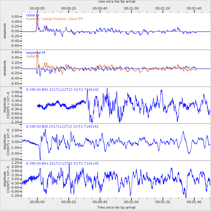
KMI Kunming, Yunnan Province, China - Earthquake Result Viewer
*The percent match for this event was below the threshold and hence no stack was calculated.
| Earthquake location: |
Off East Coast Of Honshu, Japan |
| Earthquake latitude/longitude: |
38.1/144.9 |
| Earthquake time(UTC): |
2017/11/12 (316) 22:24:07 GMT |
| Earthquake Depth: |
9.5 km |
| Earthquake Magnitude: |
5.8 Mww |
| Earthquake Catalog/Contributor: |
NEIC PDE/us |
|
| Network: |
IC New China Digital Seismograph Network |
| Station: |
KMI Kunming, Yunnan Province, China |
| Lat/Lon: |
25.12 N/102.74 E |
| Elevation: |
1975 m |
|
| Distance: |
37.8 deg |
| Az: |
262.579 deg |
| Baz: |
59.719 deg |
| Ray Param: |
$rayparam |
*The percent match for this event was below the threshold and hence was not used in the summary stack. |
|
| Radial Match: |
74.31749 % |
| Radial Bump: |
400 |
| Transverse Match: |
64.09933 % |
| Transverse Bump: |
400 |
| SOD ConfigId: |
2973751 |
| Insert Time: |
2018-10-09 01:57:58.480 +0000 |
| GWidth: |
2.5 |
| Max Bumps: |
400 |
| Tol: |
0.001 |
|
Signal To Noise
| Channel | StoN | STA | LTA |
| IC:KMI:00:BHZ:20171112T22:30:53.719014Z | 7.0731287 | 1.2031427E-6 | 1.701005E-7 |
| IC:KMI:00:BH1:20171112T22:30:53.719014Z | 2.9630094 | 4.3798784E-7 | 1.4781858E-7 |
| IC:KMI:00:BH2:20171112T22:30:53.719014Z | 4.6099424 | 6.1602077E-7 | 1.3362873E-7 |
| Arrivals |
| Ps | |
| PpPs | |
| PsPs/PpSs | |


